You are here: Home > Network List > CN - Canadian National Seismograph Network Stations List
> Station NBC7 Northern British Columbia Site Seven > Earthquake Result Viewer
NBC7 Northern British Columbia Site Seven - Earthquake Result Viewer
| Earthquake location: |
Kuril Islands |
| Earthquake latitude/longitude: |
45.6/148.9 |
| Earthquake time(UTC): |
2020/02/13 (044) 10:33:44 GMT |
| Earthquake Depth: |
144 km |
| Earthquake Magnitude: |
7.0 mww |
| Earthquake Catalog/Contributor: |
NEIC PDE/us |
|
| Network: |
CN Canadian National Seismograph Network |
| Station: |
NBC7 Northern British Columbia Site Seven |
| Lat/Lon: |
56.27 N/120.84 W |
| Elevation: |
676 m |
|
| Distance: |
53.9 deg |
| Az: |
43.695 deg |
| Baz: |
299.675 deg |
| Ray Param: |
0.06535887 |
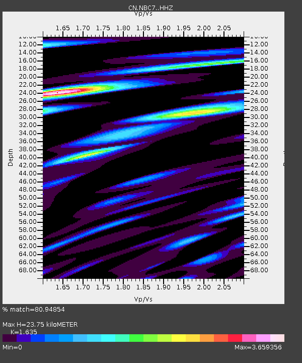
| Estimated Moho Depth: |
23.75 km |
| Estimated Crust Vp/Vs: |
1.63 |
| Assumed Crust Vp: |
6.291 km/s |
| Estimated Crust Vs: |
3.848 km/s |
| Estimated Crust Poisson's Ratio: |
0.20 |
|
| Radial Match: |
80.94854 % |
| Radial Bump: |
400 |
| Transverse Match: |
58.82506 % |
| Transverse Bump: |
400 |
| SOD ConfigId: |
20792311 |
| Insert Time: |
2020-03-06 14:34:55.101 +0000 |
| GWidth: |
2.5 |
| Max Bumps: |
400 |
| Tol: |
0.001 |
|

Signal To Noise
| Channel | StoN | STA | LTA |
| CN:NBC7: :HHZ:20200213T10:42:22.049983Z | 14.726 | 3.7103732E-6 | 2.519607E-7 |
| CN:NBC7: :HH1:20200213T10:42:22.049983Z | 1.4676611 | 1.1735386E-6 | 7.9959784E-7 |
| CN:NBC7: :HH2:20200213T10:42:22.049983Z | 2.793138 | 1.6428772E-6 | 5.8818335E-7 |
| Arrivals |
| Ps | 2.5 SECOND |
| PpPs | 9.4 SECOND |
| PsPs/PpSs | 12 SECOND |


