You are here: Home > Network List > CN - Canadian National Seismograph Network Stations List
> Station NLLB Nanaimo Lost Lake, BC, CA > Earthquake Result Viewer
NLLB Nanaimo Lost Lake, BC, CA - Earthquake Result Viewer
| Earthquake location: |
Kuril Islands |
| Earthquake latitude/longitude: |
45.6/148.9 |
| Earthquake time(UTC): |
2020/02/13 (044) 10:33:44 GMT |
| Earthquake Depth: |
144 km |
| Earthquake Magnitude: |
7.0 mww |
| Earthquake Catalog/Contributor: |
NEIC PDE/us |
|
| Network: |
CN Canadian National Seismograph Network |
| Station: |
NLLB Nanaimo Lost Lake, BC, CA |
| Lat/Lon: |
49.23 N/123.99 W |
| Elevation: |
199 m |
|
| Distance: |
55.8 deg |
| Az: |
52.297 deg |
| Baz: |
302.132 deg |
| Ray Param: |
0.06406727 |
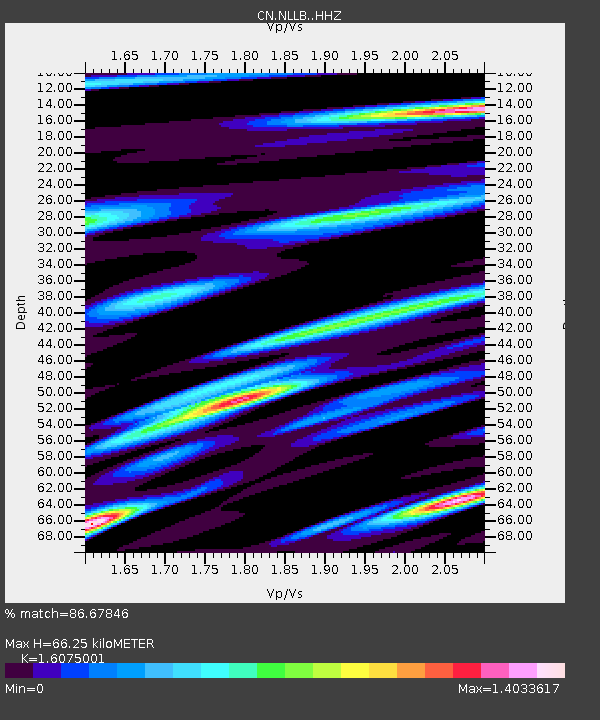
| Estimated Moho Depth: |
66.25 km |
| Estimated Crust Vp/Vs: |
1.61 |
| Assumed Crust Vp: |
6.566 km/s |
| Estimated Crust Vs: |
4.085 km/s |
| Estimated Crust Poisson's Ratio: |
0.18 |
|
| Radial Match: |
86.67846 % |
| Radial Bump: |
400 |
| Transverse Match: |
65.09376 % |
| Transverse Bump: |
400 |
| SOD ConfigId: |
20792311 |
| Insert Time: |
2020-03-06 14:35:15.959 +0000 |
| GWidth: |
2.5 |
| Max Bumps: |
400 |
| Tol: |
0.001 |
|

Signal To Noise
| Channel | StoN | STA | LTA |
| CN:NLLB: :HHZ:20200213T10:42:36.280025Z | 5.4648886 | 1.454699E-6 | 2.6619006E-7 |
| CN:NLLB: :HHN:20200213T10:42:36.280025Z | 3.2701087 | 5.464573E-7 | 1.6710675E-7 |
| CN:NLLB: :HHE:20200213T10:42:36.280025Z | 1.9569033 | 6.729904E-7 | 3.439058E-7 |
| Arrivals |
| Ps | 6.5 SECOND |
| PpPs | 25 SECOND |
| PsPs/PpSs | 31 SECOND |


