You are here: Home > Network List > CN - Canadian National Seismograph Network Stations List
> Station RES Resolute, NU, CA > Earthquake Result Viewer
RES Resolute, NU, CA - Earthquake Result Viewer
| Earthquake location: |
Kuril Islands |
| Earthquake latitude/longitude: |
45.6/148.9 |
| Earthquake time(UTC): |
2020/02/13 (044) 10:33:44 GMT |
| Earthquake Depth: |
144 km |
| Earthquake Magnitude: |
7.0 mww |
| Earthquake Catalog/Contributor: |
NEIC PDE/us |
|
| Network: |
CN Canadian National Seismograph Network |
| Station: |
RES Resolute, NU, CA |
| Lat/Lon: |
74.69 N/94.90 W |
| Elevation: |
19 m |
|
| Distance: |
52.8 deg |
| Az: |
17.421 deg |
| Baz: |
307.757 deg |
| Ray Param: |
0.06604674 |
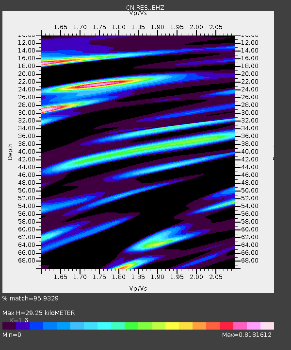
| Estimated Moho Depth: |
29.25 km |
| Estimated Crust Vp/Vs: |
1.60 |
| Assumed Crust Vp: |
6.367 km/s |
| Estimated Crust Vs: |
3.979 km/s |
| Estimated Crust Poisson's Ratio: |
0.18 |
|
| Radial Match: |
95.9329 % |
| Radial Bump: |
352 |
| Transverse Match: |
88.6142 % |
| Transverse Bump: |
400 |
| SOD ConfigId: |
20792311 |
| Insert Time: |
2020-03-06 14:37:37.909 +0000 |
| GWidth: |
2.5 |
| Max Bumps: |
400 |
| Tol: |
0.001 |
|

Signal To Noise
| Channel | StoN | STA | LTA |
| CN:RES: :BHZ:20200213T10:42:14.300014Z | 53.704945 | 1.3970235E-5 | 2.601294E-7 |
| CN:RES: :BHN:20200213T10:42:14.300014Z | 35.38306 | 4.8502625E-6 | 1.3707866E-7 |
| CN:RES: :BHE:20200213T10:42:14.300014Z | 24.38748 | 5.624792E-6 | 2.3064261E-7 |
| Arrivals |
| Ps | 2.9 SECOND |
| PpPs | 11 SECOND |
| PsPs/PpSs | 14 SECOND |


