You are here: Home > Network List > CO - South Carolina Seismic Network Stations List
> Station CASEE Lake Jocassee, SC, USA > Earthquake Result Viewer
CASEE Lake Jocassee, SC, USA - Earthquake Result Viewer
| Earthquake location: |
Kuril Islands |
| Earthquake latitude/longitude: |
45.6/148.9 |
| Earthquake time(UTC): |
2020/02/13 (044) 10:33:44 GMT |
| Earthquake Depth: |
144 km |
| Earthquake Magnitude: |
7.0 mww |
| Earthquake Catalog/Contributor: |
NEIC PDE/us |
|
| Network: |
CO South Carolina Seismic Network |
| Station: |
CASEE Lake Jocassee, SC, USA |
| Lat/Lon: |
34.99 N/82.93 W |
| Elevation: |
385 m |
|
| Distance: |
87.1 deg |
| Az: |
40.285 deg |
| Baz: |
326.455 deg |
| Ray Param: |
0.043270886 |
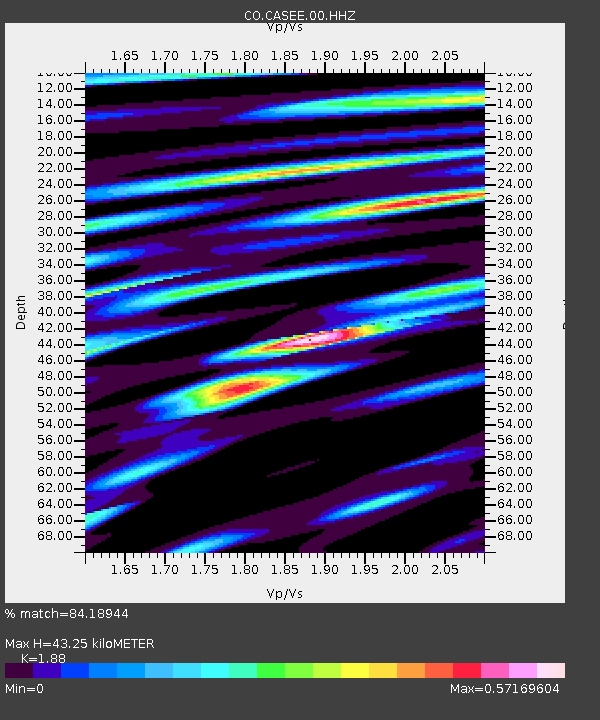
| Estimated Moho Depth: |
43.25 km |
| Estimated Crust Vp/Vs: |
1.88 |
| Assumed Crust Vp: |
6.35 km/s |
| Estimated Crust Vs: |
3.378 km/s |
| Estimated Crust Poisson's Ratio: |
0.30 |
|
| Radial Match: |
84.18944 % |
| Radial Bump: |
283 |
| Transverse Match: |
81.41238 % |
| Transverse Bump: |
391 |
| SOD ConfigId: |
20792311 |
| Insert Time: |
2020-03-06 14:42:19.135 +0000 |
| GWidth: |
2.5 |
| Max Bumps: |
400 |
| Tol: |
0.001 |
|

Signal To Noise
| Channel | StoN | STA | LTA |
| CO:CASEE:00:HHZ:20200213T10:45:42.708003Z | 6.8501997 | 2.1684903E-6 | 3.1655867E-7 |
| CO:CASEE:00:HHN:20200213T10:45:42.708003Z | 3.4116921 | 8.0626313E-7 | 2.3632353E-7 |
| CO:CASEE:00:HHE:20200213T10:45:42.708003Z | 2.0325398 | 4.5622215E-7 | 2.2445916E-7 |
| Arrivals |
| Ps | 6.1 SECOND |
| PpPs | 19 SECOND |
| PsPs/PpSs | 25 SECOND |


