You are here: Home > Network List > CZ - Czech Regional Seismic Network Stations List
> Station DPC Dobruska, Czech Republic > Earthquake Result Viewer
DPC Dobruska, Czech Republic - Earthquake Result Viewer
| Earthquake location: |
Kuril Islands |
| Earthquake latitude/longitude: |
45.6/148.9 |
| Earthquake time(UTC): |
2020/02/13 (044) 10:33:44 GMT |
| Earthquake Depth: |
144 km |
| Earthquake Magnitude: |
7.0 mww |
| Earthquake Catalog/Contributor: |
NEIC PDE/us |
|
| Network: |
CZ Czech Regional Seismic Network |
| Station: |
DPC Dobruska, Czech Republic |
| Lat/Lon: |
50.36 N/16.41 E |
| Elevation: |
760 m |
|
| Distance: |
75.9 deg |
| Az: |
330.873 deg |
| Baz: |
32.223 deg |
| Ray Param: |
0.05099927 |
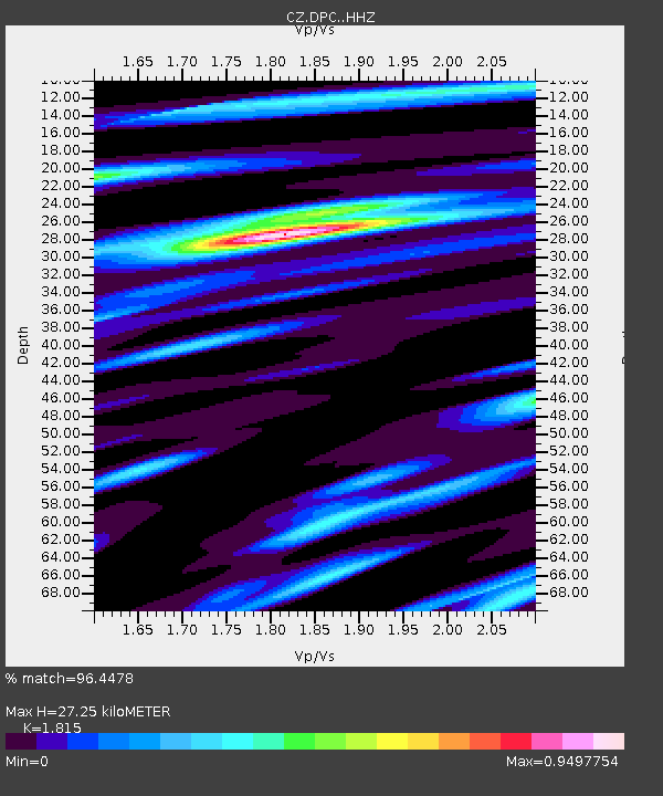
| Estimated Moho Depth: |
27.25 km |
| Estimated Crust Vp/Vs: |
1.82 |
| Assumed Crust Vp: |
6.194 km/s |
| Estimated Crust Vs: |
3.413 km/s |
| Estimated Crust Poisson's Ratio: |
0.28 |
|
| Radial Match: |
96.4478 % |
| Radial Bump: |
224 |
| Transverse Match: |
86.117744 % |
| Transverse Bump: |
343 |
| SOD ConfigId: |
20792311 |
| Insert Time: |
2020-03-06 14:43:24.472 +0000 |
| GWidth: |
2.5 |
| Max Bumps: |
400 |
| Tol: |
0.001 |
|
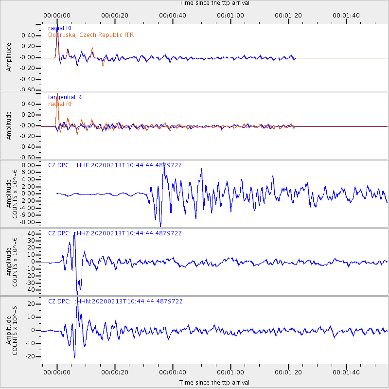
Signal To Noise
| Channel | StoN | STA | LTA |
| CZ:DPC: :HHZ:20200213T10:44:44.487972Z | 41.772343 | 1.0636514E-5 | 2.5463055E-7 |
| CZ:DPC: :HHN:20200213T10:44:44.487972Z | 11.719285 | 4.4655E-6 | 3.810386E-7 |
| CZ:DPC: :HHE:20200213T10:44:44.487972Z | 10.7565775 | 2.351011E-6 | 2.1856496E-7 |
| Arrivals |
| Ps | 3.7 SECOND |
| PpPs | 12 SECOND |
| PsPs/PpSs | 16 SECOND |


