You are here: Home > Network List > DK - Danish Seismological Network Stations List
> Station NUUK Nuuk, Greenland > Earthquake Result Viewer
NUUK Nuuk, Greenland - Earthquake Result Viewer
| Earthquake location: |
Kuril Islands |
| Earthquake latitude/longitude: |
45.6/148.9 |
| Earthquake time(UTC): |
2020/02/13 (044) 10:33:44 GMT |
| Earthquake Depth: |
144 km |
| Earthquake Magnitude: |
7.0 mww |
| Earthquake Catalog/Contributor: |
NEIC PDE/us |
|
| Network: |
DK Danish Seismological Network |
| Station: |
NUUK Nuuk, Greenland |
| Lat/Lon: |
64.18 N/51.67 W |
| Elevation: |
110 m |
|
| Distance: |
69.3 deg |
| Az: |
9.476 deg |
| Baz: |
344.703 deg |
| Ray Param: |
0.05533796 |
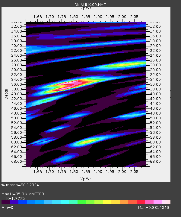
| Estimated Moho Depth: |
35.0 km |
| Estimated Crust Vp/Vs: |
1.78 |
| Assumed Crust Vp: |
6.459 km/s |
| Estimated Crust Vs: |
3.634 km/s |
| Estimated Crust Poisson's Ratio: |
0.27 |
|
| Radial Match: |
90.12034 % |
| Radial Bump: |
383 |
| Transverse Match: |
69.73758 % |
| Transverse Bump: |
400 |
| SOD ConfigId: |
20792311 |
| Insert Time: |
2020-03-06 14:47:48.083 +0000 |
| GWidth: |
2.5 |
| Max Bumps: |
400 |
| Tol: |
0.001 |
|

Signal To Noise
| Channel | StoN | STA | LTA |
| DK:NUUK:00:HHZ:20200213T10:44:05.499996Z | 10.948103 | 1.16412875E-5 | 1.0633155E-6 |
| DK:NUUK:00:HH1:20200213T10:44:05.499996Z | 9.01308 | 5.405402E-6 | 5.9972865E-7 |
| DK:NUUK:00:HH2:20200213T10:44:05.499996Z | 2.3874614 | 2.1006658E-6 | 8.798743E-7 |
| Arrivals |
| Ps | 4.4 SECOND |
| PpPs | 14 SECOND |
| PsPs/PpSs | 19 SECOND |


