You are here: Home > Network List > G - GEOSCOPE Stations List
> Station KIP Kipapa, Hawai, U.S.A. (Pacific Ocean) > Earthquake Result Viewer
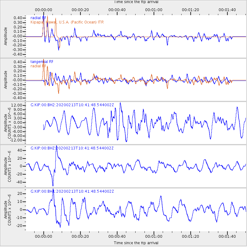
KIP Kipapa, Hawai, U.S.A. (Pacific Ocean) - Earthquake Result Viewer
*The percent match for this event was below the threshold and hence no stack was calculated.
| Earthquake location: |
Kuril Islands |
| Earthquake latitude/longitude: |
45.6/148.9 |
| Earthquake time(UTC): |
2020/02/13 (044) 10:33:44 GMT |
| Earthquake Depth: |
144 km |
| Earthquake Magnitude: |
7.0 mww |
| Earthquake Catalog/Contributor: |
NEIC PDE/us |
|
| Network: |
G GEOSCOPE |
| Station: |
KIP Kipapa, Hawai, U.S.A. (Pacific Ocean) |
| Lat/Lon: |
21.42 N/158.01 W |
| Elevation: |
70 m |
|
| Distance: |
49.3 deg |
| Az: |
100.96 deg |
| Baz: |
312.325 deg |
| Ray Param: |
$rayparam |
*The percent match for this event was below the threshold and hence was not used in the summary stack. |
|
| Radial Match: |
74.02196 % |
| Radial Bump: |
400 |
| Transverse Match: |
63.70452 % |
| Transverse Bump: |
400 |
| SOD ConfigId: |
20792311 |
| Insert Time: |
2020-03-06 14:51:23.303 +0000 |
| GWidth: |
2.5 |
| Max Bumps: |
400 |
| Tol: |
0.001 |
|
Signal To Noise
| Channel | StoN | STA | LTA |
| G:KIP:00:BHZ:20200213T10:41:48.544002Z | 2.903402 | 1.1661192E-5 | 4.0163886E-6 |
| G:KIP:00:BH1:20200213T10:41:48.544002Z | 2.9160879 | 7.3136043E-6 | 2.5080192E-6 |
| G:KIP:00:BH2:20200213T10:41:48.544002Z | 1.0937235 | 3.966494E-6 | 3.6265967E-6 |
| Arrivals |
| Ps | |
| PpPs | |
| PsPs/PpSs | |


