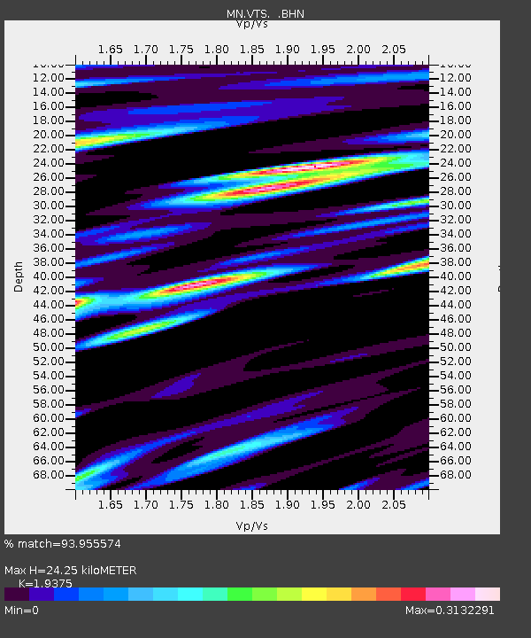
VTS Vitosha, Bulgary - Earthquake Result Viewer
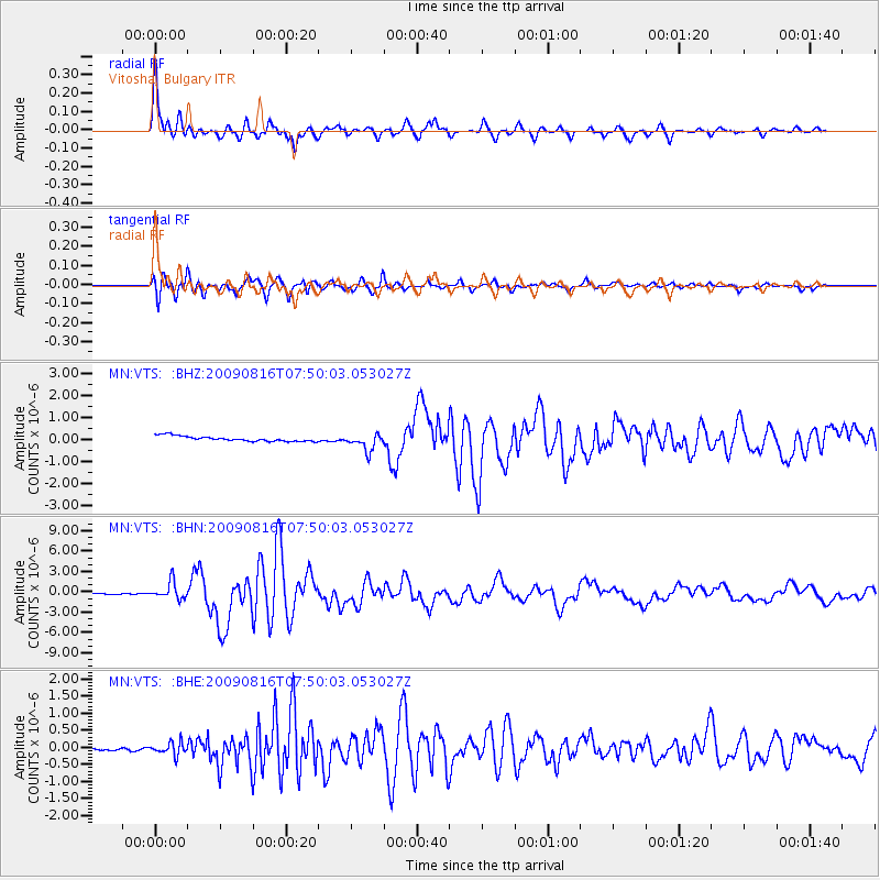
Earthquake location: Southern Sumatra, Indonesia
Earthquake latitude/longitude: -1.5/99.5
Earthquake time(UTC): 2009/08/16 (228) 07:38:21 GMT
Earthquake Depth: 20 km
Earthquake Magnitude: 6.5 MB, 6.7 MS, 6.7 MW, 6.5 MW
Earthquake Catalog/Contributor: WHDF/NEIC
Network: MN MEDNET Project
Station: VTS Vitosha, Bulgary
Lat/Lon: 42.62 N/23.24 E
Elevation: 1490 m
Distance: 80.9 deg
Az: 313.437 deg
Baz: 100.454 deg
Ray Param: 0.047940545
Estimated Moho Depth: 24.25 km
Estimated Crust Vp/Vs: 1.94
Assumed Crust Vp: 6.291 km/s
Estimated Crust Vs: 3.247 km/s
Estimated Crust Poisson's Ratio: 0.32
Radial Match: 93.955574 %
Radial Bump: 400
Transverse Match: 92.018486 %
Transverse Bump: 400
SOD ConfigId: 2622
Insert Time: 2010-03-08 17:58:08.934 +0000
GWidth: 2.5
Max Bumps: 400
Tol: 0.001

Signal To Noise

ChannelStoNSTALTA
MN:VTS: :BHN:20090816T07:50:03.053027Z23.1017951.2535024E-65.425996E-8
MN:VTS: :BHE:20090816T07:50:03.053027Z3.0815671.8550107E-76.019699E-8
MN:VTS: :BHZ:20090816T07:50:03.053027Z3.24049353.8777893E-71.1966662E-7
Arrivals
Ps3.7 SECOND
PpPs11 SECOND
PsPs/PpSs15 SECOND