You are here: Home > Network List > G - GEOSCOPE Stations List
> Station UNM Unam,Mexico > Earthquake Result Viewer
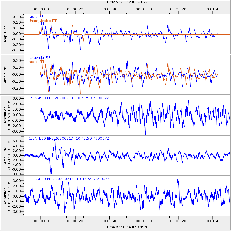
UNM Unam,Mexico - Earthquake Result Viewer
*The percent match for this event was below the threshold and hence no stack was calculated.
| Earthquake location: |
Kuril Islands |
| Earthquake latitude/longitude: |
45.6/148.9 |
| Earthquake time(UTC): |
2020/02/13 (044) 10:33:44 GMT |
| Earthquake Depth: |
144 km |
| Earthquake Magnitude: |
7.0 mww |
| Earthquake Catalog/Contributor: |
NEIC PDE/us |
|
| Network: |
G GEOSCOPE |
| Station: |
UNM Unam,Mexico |
| Lat/Lon: |
19.33 N/99.18 W |
| Elevation: |
2280 m |
|
| Distance: |
90.7 deg |
| Az: |
61.198 deg |
| Baz: |
319.374 deg |
| Ray Param: |
$rayparam |
*The percent match for this event was below the threshold and hence was not used in the summary stack. |
|
| Radial Match: |
69.34165 % |
| Radial Bump: |
400 |
| Transverse Match: |
58.59996 % |
| Transverse Bump: |
400 |
| SOD ConfigId: |
20792311 |
| Insert Time: |
2020-03-06 14:51:46.942 +0000 |
| GWidth: |
2.5 |
| Max Bumps: |
400 |
| Tol: |
0.001 |
|
Signal To Noise
| Channel | StoN | STA | LTA |
| G:UNM:00:BHZ:20200213T10:45:59.799007Z | 2.3270638 | 8.706433E-7 | 3.7413815E-7 |
| G:UNM:00:BHN:20200213T10:45:59.799007Z | 1.3260206 | 7.3834445E-7 | 5.568122E-7 |
| G:UNM:00:BHE:20200213T10:45:59.799007Z | 1.4307346 | 7.6760966E-7 | 5.3651434E-7 |
| Arrivals |
| Ps | |
| PpPs | |
| PsPs/PpSs | |


