You are here: Home > Network List > GB - Great Britain Seismograph Network Stations List
> Station CCA1 CARNMENELLIS, ENGLAND > Earthquake Result Viewer
CCA1 CARNMENELLIS, ENGLAND - Earthquake Result Viewer
| Earthquake location: |
Kuril Islands |
| Earthquake latitude/longitude: |
45.6/148.9 |
| Earthquake time(UTC): |
2020/02/13 (044) 10:33:44 GMT |
| Earthquake Depth: |
144 km |
| Earthquake Magnitude: |
7.0 mww |
| Earthquake Catalog/Contributor: |
NEIC PDE/us |
|
| Network: |
GB Great Britain Seismograph Network |
| Station: |
CCA1 CARNMENELLIS, ENGLAND |
| Lat/Lon: |
50.19 N/5.23 W |
| Elevation: |
209 m |
|
| Distance: |
82.0 deg |
| Az: |
343.561 deg |
| Baz: |
17.993 deg |
| Ray Param: |
0.04688597 |
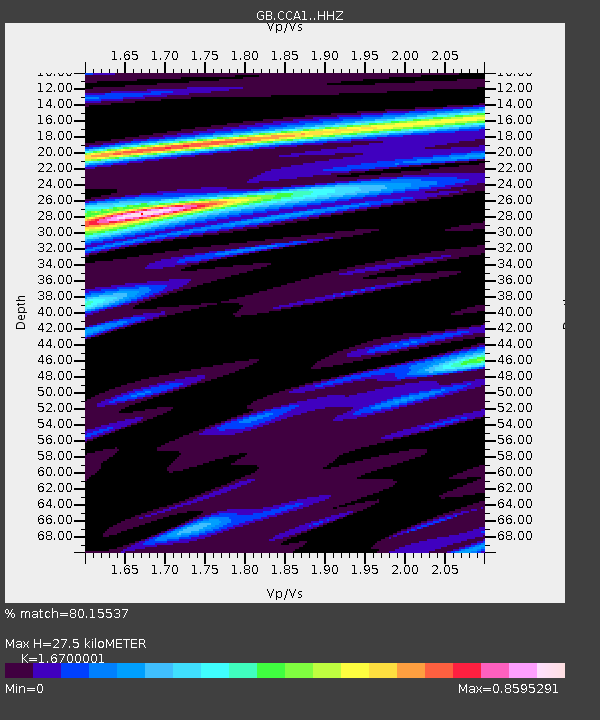
| Estimated Moho Depth: |
27.5 km |
| Estimated Crust Vp/Vs: |
1.67 |
| Assumed Crust Vp: |
6.24 km/s |
| Estimated Crust Vs: |
3.737 km/s |
| Estimated Crust Poisson's Ratio: |
0.22 |
|
| Radial Match: |
80.15537 % |
| Radial Bump: |
262 |
| Transverse Match: |
62.456215 % |
| Transverse Bump: |
349 |
| SOD ConfigId: |
20792311 |
| Insert Time: |
2020-03-06 14:52:02.745 +0000 |
| GWidth: |
2.5 |
| Max Bumps: |
400 |
| Tol: |
0.001 |
|

Signal To Noise
| Channel | StoN | STA | LTA |
| GB:CCA1: :HHZ:20200213T10:45:17.109981Z | 10.893105 | 1.7124508E-5 | 1.5720505E-6 |
| GB:CCA1: :HHN:20200213T10:45:17.109981Z | 4.914943 | 5.287868E-6 | 1.0758757E-6 |
| GB:CCA1: :HHE:20200213T10:45:17.109981Z | 2.0116436 | 2.5246018E-6 | 1.2549945E-6 |
| Arrivals |
| Ps | 3.0 SECOND |
| PpPs | 11 SECOND |
| PsPs/PpSs | 14 SECOND |


