You are here: Home > Network List > GE - GEOFON Stations List
> Station VSU GEOFON Station Vasula, Estonia > Earthquake Result Viewer
VSU GEOFON Station Vasula, Estonia - Earthquake Result Viewer
| Earthquake location: |
Kuril Islands |
| Earthquake latitude/longitude: |
45.6/148.9 |
| Earthquake time(UTC): |
2020/02/13 (044) 10:33:44 GMT |
| Earthquake Depth: |
144 km |
| Earthquake Magnitude: |
7.0 mww |
| Earthquake Catalog/Contributor: |
NEIC PDE/us |
|
| Network: |
GE GEOFON |
| Station: |
VSU GEOFON Station Vasula, Estonia |
| Lat/Lon: |
58.46 N/26.73 E |
| Elevation: |
63 m |
|
| Distance: |
65.8 deg |
| Az: |
330.818 deg |
| Baz: |
40.61 deg |
| Ray Param: |
0.057619475 |
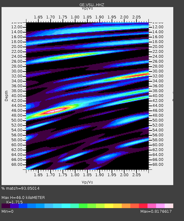
| Estimated Moho Depth: |
46.0 km |
| Estimated Crust Vp/Vs: |
1.72 |
| Assumed Crust Vp: |
6.552 km/s |
| Estimated Crust Vs: |
3.821 km/s |
| Estimated Crust Poisson's Ratio: |
0.24 |
|
| Radial Match: |
93.85014 % |
| Radial Bump: |
400 |
| Transverse Match: |
64.81166 % |
| Transverse Bump: |
400 |
| SOD ConfigId: |
20792311 |
| Insert Time: |
2020-03-06 15:02:24.527 +0000 |
| GWidth: |
2.5 |
| Max Bumps: |
400 |
| Tol: |
0.001 |
|

Signal To Noise
| Channel | StoN | STA | LTA |
| GE:VSU: :HHZ:20200213T10:43:43.520015Z | 24.248167 | 1.8121053E-5 | 7.473164E-7 |
| GE:VSU: :HHN:20200213T10:43:43.520015Z | 14.636279 | 7.986229E-6 | 5.456461E-7 |
| GE:VSU: :HHE:20200213T10:43:43.520015Z | 8.76347 | 7.395442E-6 | 8.438942E-7 |
| Arrivals |
| Ps | 5.2 SECOND |
| PpPs | 18 SECOND |
| PsPs/PpSs | 23 SECOND |


