You are here: Home > Network List > GM - US Geological Survey Networks Stations List
> Station IWM01 Jericho 2M Well Monitoring Station > Earthquake Result Viewer
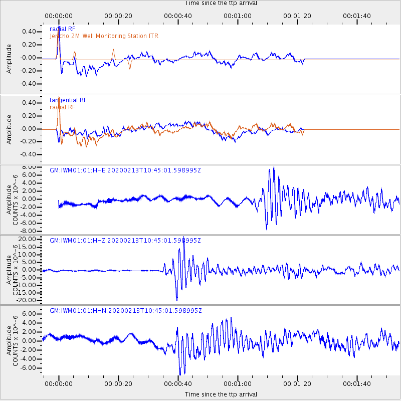
IWM01 Jericho 2M Well Monitoring Station - Earthquake Result Viewer
*The percent match for this event was below the threshold and hence no stack was calculated.
| Earthquake location: |
Kuril Islands |
| Earthquake latitude/longitude: |
45.6/148.9 |
| Earthquake time(UTC): |
2020/02/13 (044) 10:33:44 GMT |
| Earthquake Depth: |
144 km |
| Earthquake Magnitude: |
7.0 mww |
| Earthquake Catalog/Contributor: |
NEIC PDE/us |
|
| Network: |
GM US Geological Survey Networks |
| Station: |
IWM01 Jericho 2M Well Monitoring Station |
| Lat/Lon: |
36.73 N/96.53 W |
| Elevation: |
328 m |
|
| Distance: |
79.0 deg |
| Az: |
48.11 deg |
| Baz: |
319.447 deg |
| Ray Param: |
$rayparam |
*The percent match for this event was below the threshold and hence was not used in the summary stack. |
|
| Radial Match: |
66.0029 % |
| Radial Bump: |
400 |
| Transverse Match: |
47.247612 % |
| Transverse Bump: |
400 |
| SOD ConfigId: |
20792311 |
| Insert Time: |
2020-03-06 15:03:01.460 +0000 |
| GWidth: |
2.5 |
| Max Bumps: |
400 |
| Tol: |
0.001 |
|
Signal To Noise
| Channel | StoN | STA | LTA |
| GM:IWM01:01:HHZ:20200213T10:45:01.598995Z | 1.0808084 | 2.6888475E-7 | 2.4878113E-7 |
| GM:IWM01:01:HHN:20200213T10:45:01.598995Z | 1.6480668 | 1.8412519E-6 | 1.1172192E-6 |
| GM:IWM01:01:HHE:20200213T10:45:01.598995Z | 2.1997917 | 1.2509796E-6 | 5.6868095E-7 |
| Arrivals |
| Ps | |
| PpPs | |
| PsPs/PpSs | |


