You are here: Home > Network List > GS - US Geological Survey Networks Stations List
> Station DEC06 Boomer > Earthquake Result Viewer
DEC06 Boomer - Earthquake Result Viewer
| Earthquake location: |
Kuril Islands |
| Earthquake latitude/longitude: |
45.6/148.9 |
| Earthquake time(UTC): |
2020/02/13 (044) 10:33:44 GMT |
| Earthquake Depth: |
144 km |
| Earthquake Magnitude: |
7.0 mww |
| Earthquake Catalog/Contributor: |
NEIC PDE/us |
|
| Network: |
GS US Geological Survey Networks |
| Station: |
DEC06 Boomer |
| Lat/Lon: |
39.90 N/88.95 W |
| Elevation: |
215 m |
|
| Distance: |
80.3 deg |
| Az: |
41.372 deg |
| Baz: |
322.928 deg |
| Ray Param: |
0.048021384 |
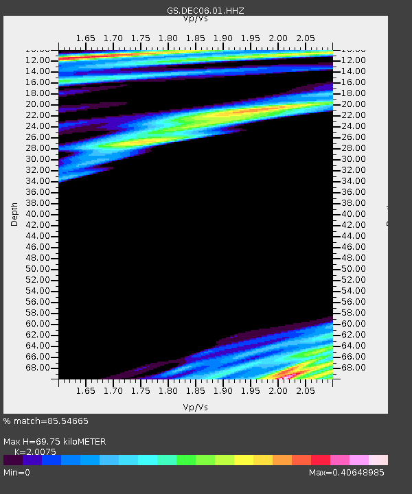
| Estimated Moho Depth: |
69.75 km |
| Estimated Crust Vp/Vs: |
2.01 |
| Assumed Crust Vp: |
6.444 km/s |
| Estimated Crust Vs: |
3.21 km/s |
| Estimated Crust Poisson's Ratio: |
0.33 |
|
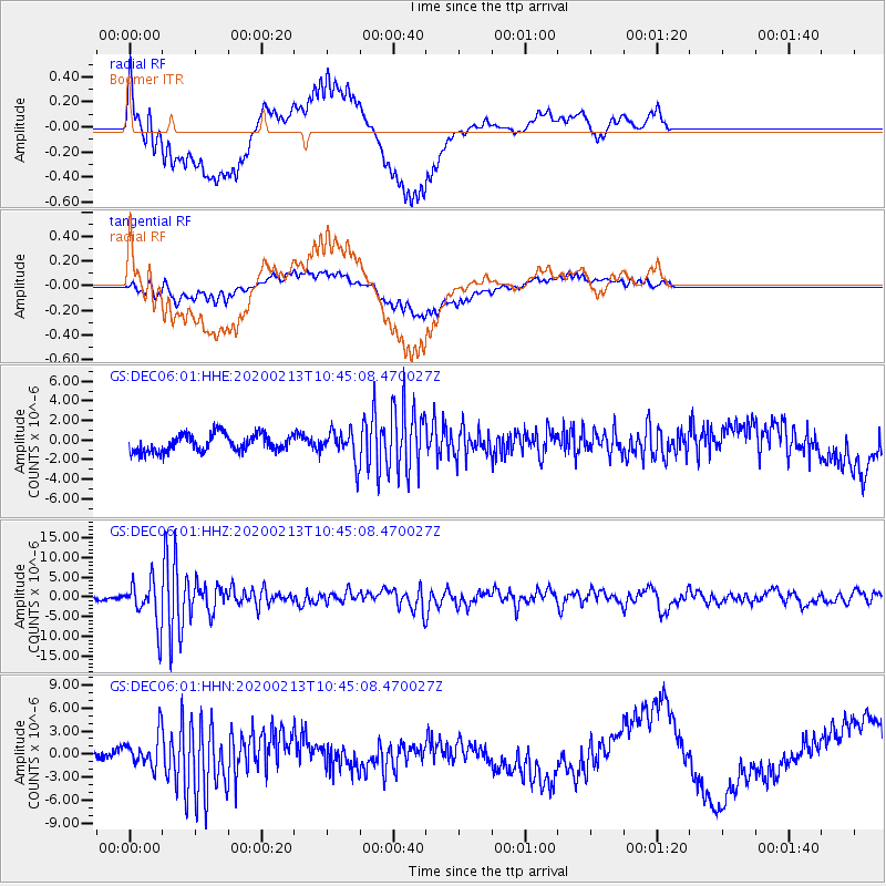
| Radial Match: |
85.54665 % |
| Radial Bump: |
400 |
| Transverse Match: |
75.22573 % |
| Transverse Bump: |
400 |
| SOD ConfigId: |
20792311 |
| Insert Time: |
2020-03-06 15:06:06.305 +0000 |
| GWidth: |
2.5 |
| Max Bumps: |
400 |
| Tol: |
0.001 |
|
Signal To Noise
| Channel | StoN | STA | LTA |
| GS:DEC06:01:HHZ:20200213T10:45:08.470027Z | 11.041344 | 5.6103013E-6 | 5.0811764E-7 |
| GS:DEC06:01:HHN:20200213T10:45:08.470027Z | 2.0914226 | 1.9867746E-6 | 9.4996335E-7 |
| GS:DEC06:01:HHE:20200213T10:45:08.470027Z | 1.7180978 | 1.5313079E-6 | 8.9128105E-7 |
| Arrivals |
| Ps | 11 SECOND |
| PpPs | 32 SECOND |
| PsPs/PpSs | 43 SECOND |


