You are here: Home > Network List > GS - US Geological Survey Networks Stations List
> Station DEC13 Justin Breden Machine Shed, Decatur, IL, USA > Earthquake Result Viewer
DEC13 Justin Breden Machine Shed, Decatur, IL, USA - Earthquake Result Viewer
| Earthquake location: |
Kuril Islands |
| Earthquake latitude/longitude: |
45.6/148.9 |
| Earthquake time(UTC): |
2020/02/13 (044) 10:33:44 GMT |
| Earthquake Depth: |
144 km |
| Earthquake Magnitude: |
7.0 mww |
| Earthquake Catalog/Contributor: |
NEIC PDE/us |
|
| Network: |
GS US Geological Survey Networks |
| Station: |
DEC13 Justin Breden Machine Shed, Decatur, IL, USA |
| Lat/Lon: |
39.90 N/88.88 W |
| Elevation: |
224 m |
|
| Distance: |
80.3 deg |
| Az: |
41.327 deg |
| Baz: |
322.963 deg |
| Ray Param: |
0.04800318 |
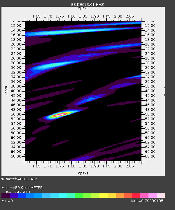
| Estimated Moho Depth: |
50.0 km |
| Estimated Crust Vp/Vs: |
1.75 |
| Assumed Crust Vp: |
6.444 km/s |
| Estimated Crust Vs: |
3.687 km/s |
| Estimated Crust Poisson's Ratio: |
0.26 |
|
| Radial Match: |
88.20436 % |
| Radial Bump: |
400 |
| Transverse Match: |
63.349873 % |
| Transverse Bump: |
400 |
| SOD ConfigId: |
20792311 |
| Insert Time: |
2020-03-06 15:06:26.078 +0000 |
| GWidth: |
2.5 |
| Max Bumps: |
400 |
| Tol: |
0.001 |
|

Signal To Noise
| Channel | StoN | STA | LTA |
| GS:DEC13:01:HHZ:20200213T10:45:08.619991Z | 11.487784 | 6.1855994E-6 | 5.384502E-7 |
| GS:DEC13:01:HHN:20200213T10:45:08.619991Z | 1.9061317 | 2.1052033E-6 | 1.1044374E-6 |
| GS:DEC13:01:HHE:20200213T10:45:08.619991Z | 1.901081 | 1.8761659E-6 | 9.868943E-7 |
| Arrivals |
| Ps | 6.0 SECOND |
| PpPs | 21 SECOND |
| PsPs/PpSs | 27 SECOND |


