You are here: Home > Network List > GS - US Geological Survey Networks Stations List
> Station OK048 Pawnee, OK, Station 48 > Earthquake Result Viewer
OK048 Pawnee, OK, Station 48 - Earthquake Result Viewer
| Earthquake location: |
Kuril Islands |
| Earthquake latitude/longitude: |
45.6/148.9 |
| Earthquake time(UTC): |
2020/02/13 (044) 10:33:44 GMT |
| Earthquake Depth: |
144 km |
| Earthquake Magnitude: |
7.0 mww |
| Earthquake Catalog/Contributor: |
NEIC PDE/us |
|
| Network: |
GS US Geological Survey Networks |
| Station: |
OK048 Pawnee, OK, Station 48 |
| Lat/Lon: |
36.42 N/96.94 W |
| Elevation: |
297 m |
|
| Distance: |
79.1 deg |
| Az: |
48.572 deg |
| Baz: |
319.29 deg |
| Ray Param: |
0.048877586 |
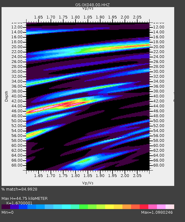
| Estimated Moho Depth: |
44.75 km |
| Estimated Crust Vp/Vs: |
1.67 |
| Assumed Crust Vp: |
6.483 km/s |
| Estimated Crust Vs: |
3.882 km/s |
| Estimated Crust Poisson's Ratio: |
0.22 |
|
| Radial Match: |
84.9928 % |
| Radial Bump: |
400 |
| Transverse Match: |
63.482143 % |
| Transverse Bump: |
400 |
| SOD ConfigId: |
20792311 |
| Insert Time: |
2020-03-06 15:06:53.270 +0000 |
| GWidth: |
2.5 |
| Max Bumps: |
400 |
| Tol: |
0.001 |
|

Signal To Noise
| Channel | StoN | STA | LTA |
| GS:OK048:00:HHZ:20200213T10:45:01.705013Z | 11.068105 | 2.9935493E-6 | 2.704663E-7 |
| GS:OK048:00:HH1:20200213T10:45:01.705013Z | 2.600677 | 8.70977E-7 | 3.3490394E-7 |
| GS:OK048:00:HH2:20200213T10:45:01.705013Z | 3.2798948 | 8.403458E-7 | 2.5621122E-7 |
| Arrivals |
| Ps | 4.8 SECOND |
| PpPs | 18 SECOND |
| PsPs/PpSs | 23 SECOND |


