You are here: Home > Network List > HK - Hong Kong Seismographic Network Stations List
> Station HKPS Po Shan, Hong Kong > Earthquake Result Viewer
HKPS Po Shan, Hong Kong - Earthquake Result Viewer
| Earthquake location: |
Kuril Islands |
| Earthquake latitude/longitude: |
45.6/148.9 |
| Earthquake time(UTC): |
2020/02/13 (044) 10:33:44 GMT |
| Earthquake Depth: |
144 km |
| Earthquake Magnitude: |
7.0 mww |
| Earthquake Catalog/Contributor: |
NEIC PDE/us |
|
| Network: |
HK Hong Kong Seismographic Network |
| Station: |
HKPS Po Shan, Hong Kong |
| Lat/Lon: |
22.28 N/114.14 E |
| Elevation: |
196 m |
|
| Distance: |
36.6 deg |
| Az: |
242.293 deg |
| Baz: |
42.12 deg |
| Ray Param: |
0.07607188 |
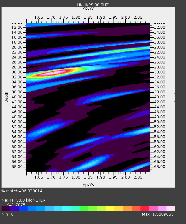
| Estimated Moho Depth: |
30.0 km |
| Estimated Crust Vp/Vs: |
1.71 |
| Assumed Crust Vp: |
6.472 km/s |
| Estimated Crust Vs: |
3.79 km/s |
| Estimated Crust Poisson's Ratio: |
0.24 |
|
| Radial Match: |
96.879814 % |
| Radial Bump: |
274 |
| Transverse Match: |
79.28725 % |
| Transverse Bump: |
400 |
| SOD ConfigId: |
20792311 |
| Insert Time: |
2020-03-06 15:07:49.994 +0000 |
| GWidth: |
2.5 |
| Max Bumps: |
400 |
| Tol: |
0.001 |
|

Signal To Noise
| Channel | StoN | STA | LTA |
| HK:HKPS:00:BHZ:20200213T10:40:06.769008Z | 14.735411 | 3.186306E-6 | 2.1623461E-7 |
| HK:HKPS:00:BHN:20200213T10:40:06.769008Z | 8.253258 | 1.2260349E-6 | 1.4855162E-7 |
| HK:HKPS:00:BHE:20200213T10:40:06.769008Z | 5.982542 | 1.2091947E-6 | 2.0212056E-7 |
| Arrivals |
| Ps | 3.5 SECOND |
| PpPs | 12 SECOND |
| PsPs/PpSs | 15 SECOND |


