You are here: Home > Network List > II - Global Seismograph Network (GSN - IRIS/IDA) Stations List
> Station KURK Kurchatov, Kazakhstan > Earthquake Result Viewer
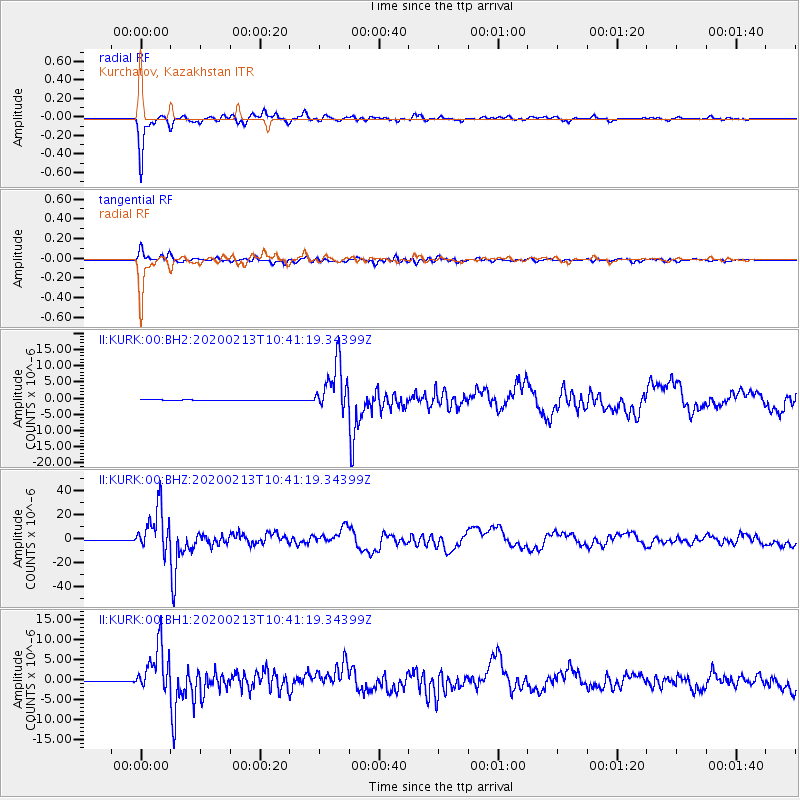
KURK Kurchatov, Kazakhstan - Earthquake Result Viewer
*The percent match for this event was below the threshold and hence no stack was calculated.
| Earthquake location: |
Kuril Islands |
| Earthquake latitude/longitude: |
45.6/148.9 |
| Earthquake time(UTC): |
2020/02/13 (044) 10:33:44 GMT |
| Earthquake Depth: |
144 km |
| Earthquake Magnitude: |
7.0 mww |
| Earthquake Catalog/Contributor: |
NEIC PDE/us |
|
| Network: |
II Global Seismograph Network (GSN - IRIS/IDA) |
| Station: |
KURK Kurchatov, Kazakhstan |
| Lat/Lon: |
50.72 N/78.62 E |
| Elevation: |
184 m |
|
| Distance: |
45.5 deg |
| Az: |
303.021 deg |
| Baz: |
67.737 deg |
| Ray Param: |
$rayparam |
*The percent match for this event was below the threshold and hence was not used in the summary stack. |
|
| Radial Match: |
97.17825 % |
| Radial Bump: |
258 |
| Transverse Match: |
91.44023 % |
| Transverse Bump: |
400 |
| SOD ConfigId: |
20792311 |
| Insert Time: |
2020-03-06 15:13:42.543 +0000 |
| GWidth: |
2.5 |
| Max Bumps: |
400 |
| Tol: |
0.001 |
|
Signal To Noise
| Channel | StoN | STA | LTA |
| II:KURK:00:BHZ:20200213T10:41:19.34399Z | 104.72069 | 1.78895E-5 | 1.7083063E-7 |
| II:KURK:00:BH1:20200213T10:41:19.34399Z | 47.567844 | 5.844845E-6 | 1.2287387E-7 |
| II:KURK:00:BH2:20200213T10:41:19.34399Z | 74.27135 | 7.5501994E-6 | 1.01656966E-7 |
| Arrivals |
| Ps | |
| PpPs | |
| PsPs/PpSs | |


