You are here: Home > Network List > IU - Global Seismograph Network (GSN - IRIS/USGS) Stations List
> Station KIEV Kiev, Ukraine > Earthquake Result Viewer
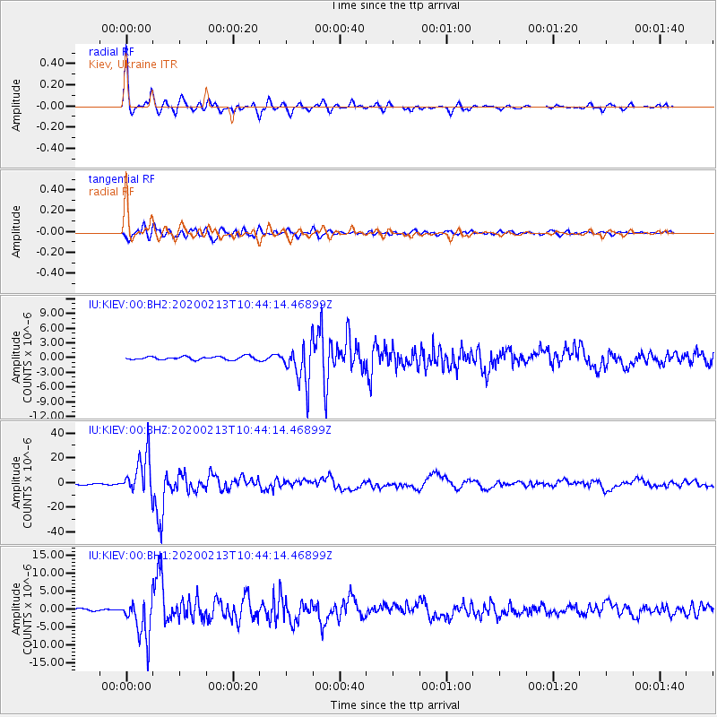
KIEV Kiev, Ukraine - Earthquake Result Viewer

| Earthquake location: |
Kuril Islands |
| Earthquake latitude/longitude: |
45.6/148.9 |
| Earthquake time(UTC): |
2020/02/13 (044) 10:33:44 GMT |
| Earthquake Depth: |
144 km |
| Earthquake Magnitude: |
7.0 mww |
| Earthquake Catalog/Contributor: |
NEIC PDE/us |
|
| Network: |
IU Global Seismograph Network (GSN - IRIS/USGS) |
| Station: |
KIEV Kiev, Ukraine |
| Lat/Lon: |
50.70 N/29.22 E |
| Elevation: |
180 m |
|
| Distance: |
70.8 deg |
| Az: |
324.207 deg |
| Baz: |
40.191 deg |
| Ray Param: |
0.054373767 |
| Estimated Moho Depth: |
37.5 km |
| Estimated Crust Vp/Vs: |
1.81 |
| Assumed Crust Vp: |
6.552 km/s |
| Estimated Crust Vs: |
3.62 km/s |
| Estimated Crust Poisson's Ratio: |
0.28 |
|
| Radial Match: |
96.134674 % |
| Radial Bump: |
375 |
| Transverse Match: |
91.049965 % |
| Transverse Bump: |
400 |
| SOD ConfigId: |
20792311 |
| Insert Time: |
2020-03-06 15:18:49.556 +0000 |
| GWidth: |
2.5 |
| Max Bumps: |
400 |
| Tol: |
0.001 |
|
Signal To Noise
| Channel | StoN | STA | LTA |
| IU:KIEV:00:BHZ:20200213T10:44:14.46899Z | 37.376427 | 1.6285809E-5 | 4.3572408E-7 |
| IU:KIEV:00:BH1:20200213T10:44:14.46899Z | 21.73895 | 5.6290805E-6 | 2.5893982E-7 |
| IU:KIEV:00:BH2:20200213T10:44:14.46899Z | 11.734695 | 3.99022E-6 | 3.400361E-7 |
| Arrivals |
| Ps | 4.8 SECOND |
| PpPs | 16 SECOND |
| PsPs/PpSs | 20 SECOND |


