You are here: Home > Network List > IU - Global Seismograph Network (GSN - IRIS/USGS) Stations List
> Station PMG Port Moresby, New Guinea > Earthquake Result Viewer
PMG Port Moresby, New Guinea - Earthquake Result Viewer
| Earthquake location: |
Kuril Islands |
| Earthquake latitude/longitude: |
45.6/148.9 |
| Earthquake time(UTC): |
2020/02/13 (044) 10:33:44 GMT |
| Earthquake Depth: |
144 km |
| Earthquake Magnitude: |
7.0 mww |
| Earthquake Catalog/Contributor: |
NEIC PDE/us |
|
| Network: |
IU Global Seismograph Network (GSN - IRIS/USGS) |
| Station: |
PMG Port Moresby, New Guinea |
| Lat/Lon: |
9.40 S/147.16 E |
| Elevation: |
90 m |
|
| Distance: |
54.8 deg |
| Az: |
182.137 deg |
| Baz: |
1.519 deg |
| Ray Param: |
0.06473398 |
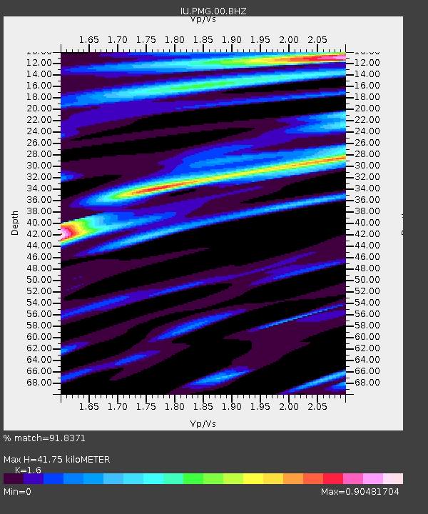
| Estimated Moho Depth: |
41.75 km |
| Estimated Crust Vp/Vs: |
1.60 |
| Assumed Crust Vp: |
6.122 km/s |
| Estimated Crust Vs: |
3.826 km/s |
| Estimated Crust Poisson's Ratio: |
0.18 |
|
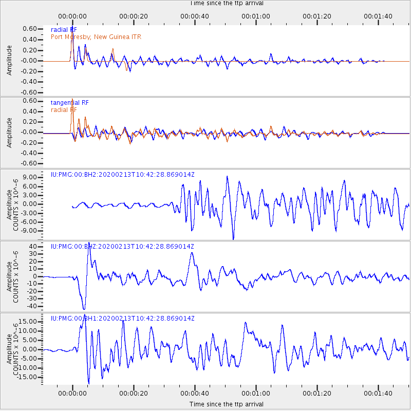
| Radial Match: |
91.8371 % |
| Radial Bump: |
378 |
| Transverse Match: |
87.596085 % |
| Transverse Bump: |
400 |
| SOD ConfigId: |
20792311 |
| Insert Time: |
2020-03-06 15:19:45.968 +0000 |
| GWidth: |
2.5 |
| Max Bumps: |
400 |
| Tol: |
0.001 |
|
Signal To Noise
| Channel | StoN | STA | LTA |
| IU:PMG:00:BHZ:20200213T10:42:28.869014Z | 65.78355 | 2.0857036E-5 | 3.170555E-7 |
| IU:PMG:00:BH1:20200213T10:42:28.869014Z | 17.172283 | 9.096003E-6 | 5.2969096E-7 |
| IU:PMG:00:BH2:20200213T10:42:28.869014Z | 1.7718966 | 9.628229E-7 | 5.433855E-7 |
| Arrivals |
| Ps | 4.3 SECOND |
| PpPs | 17 SECOND |
| PsPs/PpSs | 21 SECOND |


