You are here: Home > Network List > IU - Global Seismograph Network (GSN - IRIS/USGS) Stations List
> Station TATO Taipei, Taiwan > Earthquake Result Viewer
TATO Taipei, Taiwan - Earthquake Result Viewer
| Earthquake location: |
Kuril Islands |
| Earthquake latitude/longitude: |
45.6/148.9 |
| Earthquake time(UTC): |
2020/02/13 (044) 10:33:44 GMT |
| Earthquake Depth: |
144 km |
| Earthquake Magnitude: |
7.0 mww |
| Earthquake Catalog/Contributor: |
NEIC PDE/us |
|
| Network: |
IU Global Seismograph Network (GSN - IRIS/USGS) |
| Station: |
TATO Taipei, Taiwan |
| Lat/Lon: |
24.97 N/121.50 E |
| Elevation: |
160 m |
|
| Distance: |
30.2 deg |
| Az: |
236.255 deg |
| Baz: |
40.005 deg |
| Ray Param: |
0.07917949 |
| Estimated Moho Depth: |
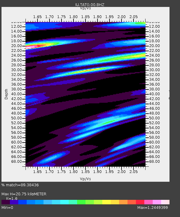
20.75 km |
| Estimated Crust Vp/Vs: |
1.60 |
| Assumed Crust Vp: |
6.289 km/s |
| Estimated Crust Vs: |
3.93 km/s |
| Estimated Crust Poisson's Ratio: |
0.18 |
|
| Radial Match: |
89.38436 % |
| Radial Bump: |
400 |
| Transverse Match: |
64.46402 % |
| Transverse Bump: |
400 |
| SOD ConfigId: |
20792311 |
| Insert Time: |
2020-03-06 15:20:59.535 +0000 |
| GWidth: |
2.5 |
| Max Bumps: |
400 |
| Tol: |
0.001 |
|

Signal To Noise
| Channel | StoN | STA | LTA |
| IU:TATO:00:BHZ:20200213T10:39:11.019008Z | 5.9369454 | 4.949296E-6 | 8.3364347E-7 |
| IU:TATO:00:BH1:20200213T10:39:11.019008Z | 1.1782683 | 1.5402421E-6 | 1.3072083E-6 |
| IU:TATO:00:BH2:20200213T10:39:11.019008Z | 3.3649926 | 2.7454373E-6 | 8.158821E-7 |
| Arrivals |
| Ps | 2.2 SECOND |
| PpPs | 7.9 SECOND |
| PsPs/PpSs | 10 SECOND |


