You are here: Home > Network List > KZ - Kazakhstan Network Stations List
> Station PDGK Podgonoye, Kazakstan > Earthquake Result Viewer
PDGK Podgonoye, Kazakstan - Earthquake Result Viewer
| Earthquake location: |
Kuril Islands |
| Earthquake latitude/longitude: |
45.6/148.9 |
| Earthquake time(UTC): |
2020/02/13 (044) 10:33:44 GMT |
| Earthquake Depth: |
144 km |
| Earthquake Magnitude: |
7.0 mww |
| Earthquake Catalog/Contributor: |
NEIC PDE/us |
|
| Network: |
KZ Kazakhstan Network |
| Station: |
PDGK Podgonoye, Kazakstan |
| Lat/Lon: |
43.33 N/79.48 E |
| Elevation: |
1290 m |
|
| Distance: |
48.2 deg |
| Az: |
293.507 deg |
| Baz: |
61.853 deg |
| Ray Param: |
0.06902186 |
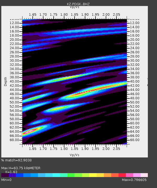
| Estimated Moho Depth: |
63.75 km |
| Estimated Crust Vp/Vs: |
1.63 |
| Assumed Crust Vp: |
6.306 km/s |
| Estimated Crust Vs: |
3.869 km/s |
| Estimated Crust Poisson's Ratio: |
0.20 |
|
| Radial Match: |
92.9038 % |
| Radial Bump: |
400 |
| Transverse Match: |
78.908714 % |
| Transverse Bump: |
400 |
| SOD ConfigId: |
20792311 |
| Insert Time: |
2020-03-06 15:30:26.098 +0000 |
| GWidth: |
2.5 |
| Max Bumps: |
400 |
| Tol: |
0.001 |
|

Signal To Noise
| Channel | StoN | STA | LTA |
| KZ:PDGK: :BHZ:20200213T10:41:39.64999Z | 126.28626 | 1.715175E-5 | 1.3581644E-7 |
| KZ:PDGK: :BHN:20200213T10:41:39.64999Z | 68.00521 | 6.076286E-6 | 8.9350294E-8 |
| KZ:PDGK: :BHE:20200213T10:41:39.64999Z | 90.27676 | 7.887273E-6 | 8.7367695E-8 |
| Arrivals |
| Ps | 6.8 SECOND |
| PpPs | 25 SECOND |
| PsPs/PpSs | 32 SECOND |


