You are here: Home > Network List > MB - Montana Regional Seismic Network Stations List
> Station BUT Butte, Montana > Earthquake Result Viewer
BUT Butte, Montana - Earthquake Result Viewer
| Earthquake location: |
Kuril Islands |
| Earthquake latitude/longitude: |
45.6/148.9 |
| Earthquake time(UTC): |
2020/02/13 (044) 10:33:44 GMT |
| Earthquake Depth: |
144 km |
| Earthquake Magnitude: |
7.0 mww |
| Earthquake Catalog/Contributor: |
NEIC PDE/us |
|
| Network: |
MB Montana Regional Seismic Network |
| Station: |
BUT Butte, Montana |
| Lat/Lon: |
46.01 N/112.56 W |
| Elevation: |
1758 m |
|
| Distance: |
64.0 deg |
| Az: |
50.08 deg |
| Baz: |
309.452 deg |
| Ray Param: |
0.058808386 |
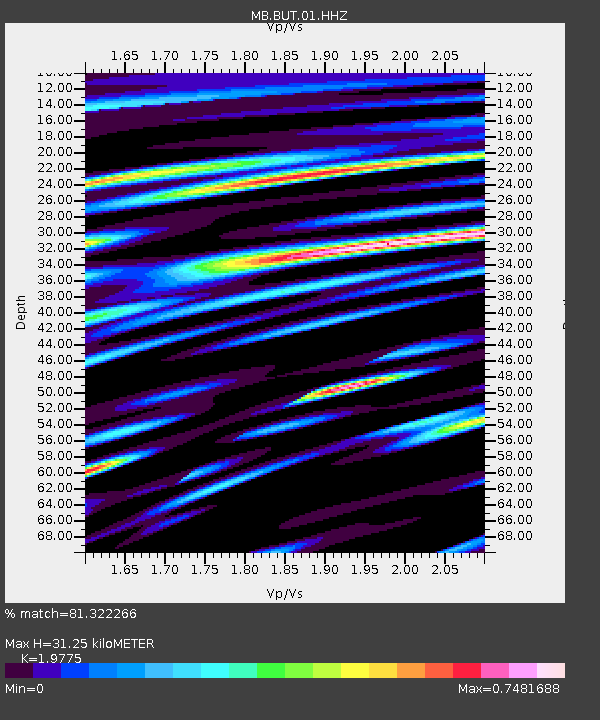
| Estimated Moho Depth: |
31.25 km |
| Estimated Crust Vp/Vs: |
1.98 |
| Assumed Crust Vp: |
6.353 km/s |
| Estimated Crust Vs: |
3.213 km/s |
| Estimated Crust Poisson's Ratio: |
0.33 |
|
| Radial Match: |
81.322266 % |
| Radial Bump: |
389 |
| Transverse Match: |
72.67831 % |
| Transverse Bump: |
400 |
| SOD ConfigId: |
20792311 |
| Insert Time: |
2020-03-06 15:38:23.624 +0000 |
| GWidth: |
2.5 |
| Max Bumps: |
400 |
| Tol: |
0.001 |
|

Signal To Noise
| Channel | StoN | STA | LTA |
| MB:BUT:01:HHZ:20200213T10:43:31.720027Z | 4.44237 | 2.8695865E-6 | 6.4595844E-7 |
| MB:BUT:01:HHN:20200213T10:43:31.720027Z | 3.0575907 | 1.3544656E-6 | 4.4298457E-7 |
| MB:BUT:01:HHE:20200213T10:43:31.720027Z | 1.5706322 | 1.1853311E-6 | 7.546841E-7 |
| Arrivals |
| Ps | 5.0 SECOND |
| PpPs | 14 SECOND |
| PsPs/PpSs | 19 SECOND |


