You are here: Home > Network List > TS - TERRAscope (Southern California Seismic Network) Stations List
> Station PFO Pinon Flat, California, USA > Earthquake Result Viewer
PFO Pinon Flat, California, USA - Earthquake Result Viewer
*The percent match for this event was below the threshold and hence no stack was calculated.
| Earthquake location: |
Near Coast Of Peru |
| Earthquake latitude/longitude: |
-14.9/-75.6 |
| Earthquake time(UTC): |
1996/11/12 (317) 17:10:00 GMT |
| Earthquake Depth: |
33 km |
| Earthquake Magnitude: |
5.6 MB |
| Earthquake Catalog/Contributor: |
WHDF/NEIC |
|
| Network: |
TS TERRAscope (Southern California Seismic Network) |
| Station: |
PFO Pinon Flat, California, USA |
| Lat/Lon: |
33.61 N/116.46 W |
| Elevation: |
1280 m |
|
| Distance: |
62.0 deg |
| Az: |
321.826 deg |
| Baz: |
134.284 deg |
| Ray Param: |
$rayparam |
*The percent match for this event was below the threshold and hence was not used in the summary stack. |
|
| Radial Match: |
34.041363 % |
| Radial Bump: |
334 |
| Transverse Match: |
66.43662 % |
| Transverse Bump: |
400 |
| SOD ConfigId: |
4480 |
| Insert Time: |
2010-02-26 14:43:06.335 +0000 |
| GWidth: |
2.5 |
| Max Bumps: |
400 |
| Tol: |
0.001 |
|
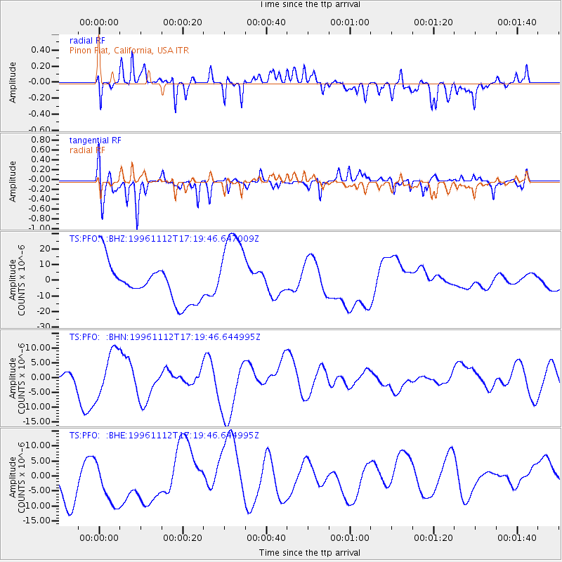
Signal To Noise
| Channel | StoN | STA | LTA |
| TS:PFO: :BHN:19961112T17:19:46.644995Z | 1.329696 | 7.4850836E-6 | 5.6291688E-6 |
| TS:PFO: :BHE:19961112T17:19:46.644995Z | 0.66444916 | 7.940976E-6 | 1.1951217E-5 |
| TS:PFO: :BHZ:19961112T17:19:46.647009Z | 2.2038767 | 2.6497266E-5 | 1.2023026E-5 |
| Arrivals |
| Ps | |
| PpPs | |
| PsPs/PpSs | |


