You are here: Home > Network List > N4 - Central and EAstern US Network Stations List
> Station F33B 5 Mile Ranch, Herman, MN, USA > Earthquake Result Viewer
F33B 5 Mile Ranch, Herman, MN, USA - Earthquake Result Viewer
| Earthquake location: |
Kuril Islands |
| Earthquake latitude/longitude: |
45.6/148.9 |
| Earthquake time(UTC): |
2020/02/13 (044) 10:33:44 GMT |
| Earthquake Depth: |
144 km |
| Earthquake Magnitude: |
7.0 mww |
| Earthquake Catalog/Contributor: |
NEIC PDE/us |
|
| Network: |
N4 Central and EAstern US Network |
| Station: |
F33B 5 Mile Ranch, Herman, MN, USA |
| Lat/Lon: |
45.84 N/96.29 W |
| Elevation: |
314 m |
|
| Distance: |
72.3 deg |
| Az: |
41.776 deg |
| Baz: |
318.033 deg |
| Ray Param: |
0.053388387 |
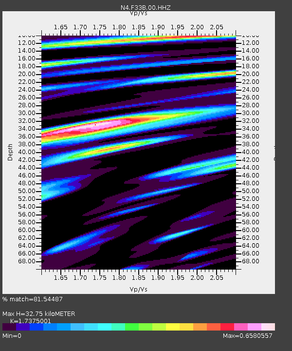
| Estimated Moho Depth: |
32.75 km |
| Estimated Crust Vp/Vs: |
1.74 |
| Assumed Crust Vp: |
6.552 km/s |
| Estimated Crust Vs: |
3.771 km/s |
| Estimated Crust Poisson's Ratio: |
0.25 |
|
| Radial Match: |
81.54487 % |
| Radial Bump: |
341 |
| Transverse Match: |
53.32602 % |
| Transverse Bump: |
288 |
| SOD ConfigId: |
20792311 |
| Insert Time: |
2020-03-06 15:49:05.814 +0000 |
| GWidth: |
2.5 |
| Max Bumps: |
400 |
| Tol: |
0.001 |
|

Signal To Noise
| Channel | StoN | STA | LTA |
| N4:F33B:00:HHZ:20200213T10:44:23.439998Z | 17.287489 | 4.7982617E-6 | 2.775569E-7 |
| N4:F33B:00:HH1:20200213T10:44:23.439998Z | 4.8103046 | 1.484707E-6 | 3.0865135E-7 |
| N4:F33B:00:HH2:20200213T10:44:23.439998Z | 4.1286006 | 1.6478989E-6 | 3.9914224E-7 |
| Arrivals |
| Ps | 3.8 SECOND |
| PpPs | 13 SECOND |
| PsPs/PpSs | 17 SECOND |


