You are here: Home > Network List > N4 - Central and EAstern US Network Stations List
> Station K30B Basset, NE, USA > Earthquake Result Viewer
K30B Basset, NE, USA - Earthquake Result Viewer
| Earthquake location: |
Kuril Islands |
| Earthquake latitude/longitude: |
45.6/148.9 |
| Earthquake time(UTC): |
2020/02/13 (044) 10:33:44 GMT |
| Earthquake Depth: |
144 km |
| Earthquake Magnitude: |
7.0 mww |
| Earthquake Catalog/Contributor: |
NEIC PDE/us |
|
| Network: |
N4 Central and EAstern US Network |
| Station: |
K30B Basset, NE, USA |
| Lat/Lon: |
42.67 N/99.61 W |
| Elevation: |
712 m |
|
| Distance: |
73.0 deg |
| Az: |
45.858 deg |
| Baz: |
316.939 deg |
| Ray Param: |
0.052909043 |
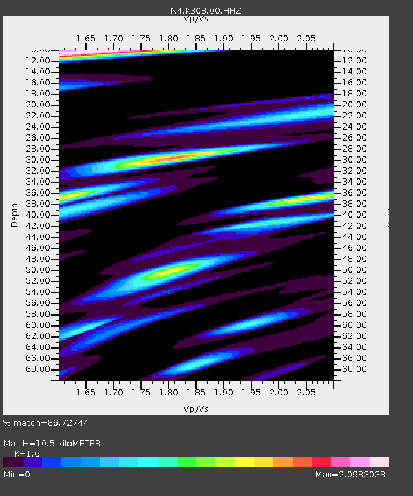
| Estimated Moho Depth: |
10.5 km |
| Estimated Crust Vp/Vs: |
1.60 |
| Assumed Crust Vp: |
6.53 km/s |
| Estimated Crust Vs: |
4.082 km/s |
| Estimated Crust Poisson's Ratio: |
0.18 |
|
| Radial Match: |
86.72744 % |
| Radial Bump: |
400 |
| Transverse Match: |
72.0553 % |
| Transverse Bump: |
400 |
| SOD ConfigId: |
20792311 |
| Insert Time: |
2020-03-06 15:51:02.019 +0000 |
| GWidth: |
2.5 |
| Max Bumps: |
400 |
| Tol: |
0.001 |
|

Signal To Noise
| Channel | StoN | STA | LTA |
| N4:K30B:00:HHZ:20200213T10:44:27.679988Z | 28.044209 | 4.016001E-6 | 1.4320253E-7 |
| N4:K30B:00:HH1:20200213T10:44:27.679988Z | 3.1505258 | 1.5350857E-6 | 4.8724746E-7 |
| N4:K30B:00:HH2:20200213T10:44:27.679988Z | 2.4662883 | 1.0701201E-6 | 4.3389903E-7 |
| Arrivals |
| Ps | 1.0 SECOND |
| PpPs | 4.0 SECOND |
| PsPs/PpSs | 5.0 SECOND |


