You are here: Home > Network List > N4 - Central and EAstern US Network Stations List
> Station L34B Svendsen Farm, Lyons, NE, USA > Earthquake Result Viewer
L34B Svendsen Farm, Lyons, NE, USA - Earthquake Result Viewer
| Earthquake location: |
Kuril Islands |
| Earthquake latitude/longitude: |
45.6/148.9 |
| Earthquake time(UTC): |
2020/02/13 (044) 10:33:44 GMT |
| Earthquake Depth: |
144 km |
| Earthquake Magnitude: |
7.0 mww |
| Earthquake Catalog/Contributor: |
NEIC PDE/us |
|
| Network: |
N4 Central and EAstern US Network |
| Station: |
L34B Svendsen Farm, Lyons, NE, USA |
| Lat/Lon: |
41.97 N/96.38 W |
| Elevation: |
414 m |
|
| Distance: |
75.2 deg |
| Az: |
44.502 deg |
| Baz: |
318.739 deg |
| Ray Param: |
0.051498793 |
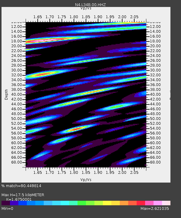
| Estimated Moho Depth: |
17.5 km |
| Estimated Crust Vp/Vs: |
1.68 |
| Assumed Crust Vp: |
6.498 km/s |
| Estimated Crust Vs: |
3.879 km/s |
| Estimated Crust Poisson's Ratio: |
0.22 |
|
| Radial Match: |
90.449814 % |
| Radial Bump: |
400 |
| Transverse Match: |
84.20616 % |
| Transverse Bump: |
400 |
| SOD ConfigId: |
20792311 |
| Insert Time: |
2020-03-06 15:51:57.691 +0000 |
| GWidth: |
2.5 |
| Max Bumps: |
400 |
| Tol: |
0.001 |
|

Signal To Noise
| Channel | StoN | STA | LTA |
| N4:L34B:00:HHZ:20200213T10:44:40.030025Z | 15.376649 | 4.7110047E-6 | 3.0637395E-7 |
| N4:L34B:00:HH1:20200213T10:44:40.030025Z | 6.8066387 | 3.1339716E-6 | 4.6042868E-7 |
| N4:L34B:00:HH2:20200213T10:44:40.030025Z | 6.49914 | 2.7615715E-6 | 4.2491342E-7 |
| Arrivals |
| Ps | 1.9 SECOND |
| PpPs | 7.0 SECOND |
| PsPs/PpSs | 8.8 SECOND |


