You are here: Home > Network List > N4 - Central and EAstern US Network Stations List
> Station T42B Van Buren, MO, USA > Earthquake Result Viewer
T42B Van Buren, MO, USA - Earthquake Result Viewer
| Earthquake location: |
Kuril Islands |
| Earthquake latitude/longitude: |
45.6/148.9 |
| Earthquake time(UTC): |
2020/02/13 (044) 10:33:44 GMT |
| Earthquake Depth: |
144 km |
| Earthquake Magnitude: |
7.0 mww |
| Earthquake Catalog/Contributor: |
NEIC PDE/us |
|
| Network: |
N4 Central and EAstern US Network |
| Station: |
T42B Van Buren, MO, USA |
| Lat/Lon: |
37.03 N/91.09 W |
| Elevation: |
165 m |
|
| Distance: |
81.6 deg |
| Az: |
44.489 deg |
| Baz: |
322.089 deg |
| Ray Param: |
0.04715727 |
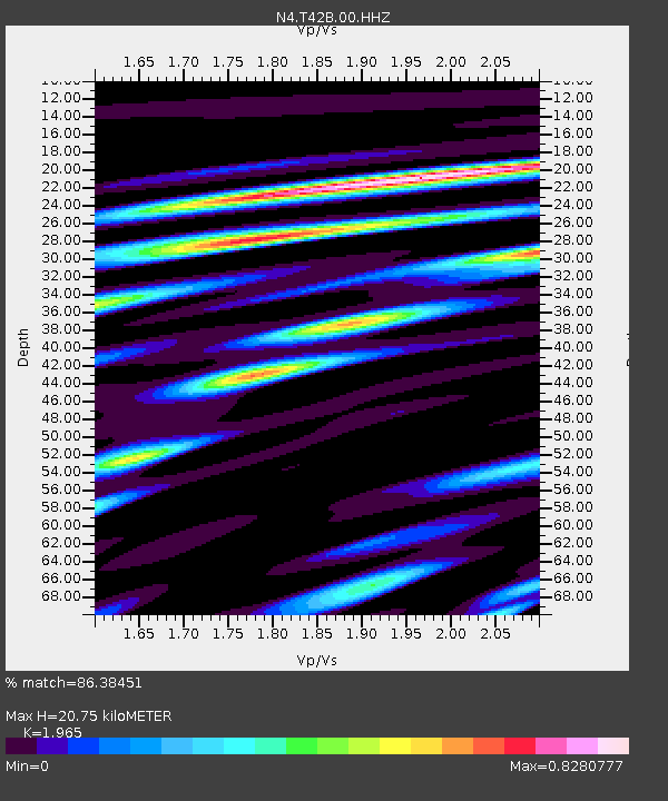
| Estimated Moho Depth: |
20.75 km |
| Estimated Crust Vp/Vs: |
1.97 |
| Assumed Crust Vp: |
6.53 km/s |
| Estimated Crust Vs: |
3.323 km/s |
| Estimated Crust Poisson's Ratio: |
0.33 |
|
| Radial Match: |
86.38451 % |
| Radial Bump: |
363 |
| Transverse Match: |
72.84469 % |
| Transverse Bump: |
400 |
| SOD ConfigId: |
20792311 |
| Insert Time: |
2020-03-06 15:57:51.187 +0000 |
| GWidth: |
2.5 |
| Max Bumps: |
400 |
| Tol: |
0.001 |
|

Signal To Noise
| Channel | StoN | STA | LTA |
| N4:T42B:00:HHZ:20200213T10:45:15.049007Z | 13.176835 | 3.7386853E-6 | 2.8373165E-7 |
| N4:T42B:00:HH1:20200213T10:45:15.049007Z | 4.2361584 | 1.4436434E-6 | 3.407907E-7 |
| N4:T42B:00:HH2:20200213T10:45:15.049007Z | 3.8759832 | 1.0970391E-6 | 2.8303506E-7 |
| Arrivals |
| Ps | 3.1 SECOND |
| PpPs | 9.2 SECOND |
| PsPs/PpSs | 12 SECOND |


