You are here: Home > Network List > NM - Cooperative New Madrid Seismic Network Stations List
> Station HALT Halls,TN > Earthquake Result Viewer
HALT Halls,TN - Earthquake Result Viewer
| Earthquake location: |
Kuril Islands |
| Earthquake latitude/longitude: |
45.6/148.9 |
| Earthquake time(UTC): |
2020/02/13 (044) 10:33:44 GMT |
| Earthquake Depth: |
144 km |
| Earthquake Magnitude: |
7.0 mww |
| Earthquake Catalog/Contributor: |
NEIC PDE/us |
|
| Network: |
NM Cooperative New Madrid Seismic Network |
| Station: |
HALT Halls,TN |
| Lat/Lon: |
35.91 N/89.34 W |
| Elevation: |
85 m |
|
| Distance: |
83.3 deg |
| Az: |
44.042 deg |
| Baz: |
323.067 deg |
| Ray Param: |
0.045946628 |
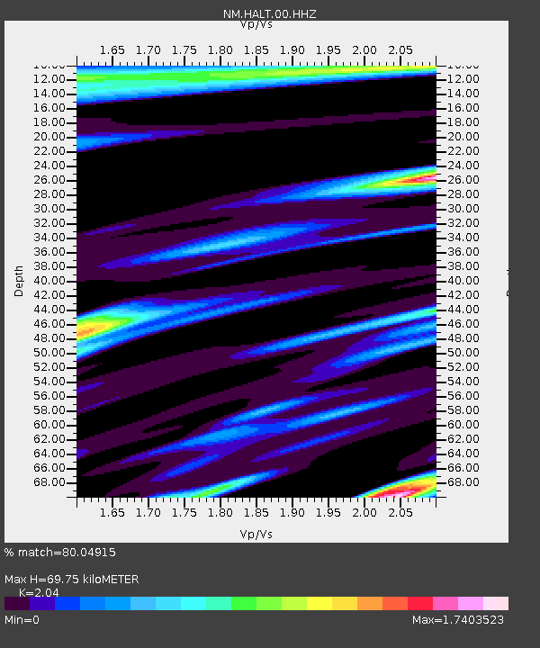
| Estimated Moho Depth: |
69.75 km |
| Estimated Crust Vp/Vs: |
2.04 |
| Assumed Crust Vp: |
6.38 km/s |
| Estimated Crust Vs: |
3.128 km/s |
| Estimated Crust Poisson's Ratio: |
0.34 |
|
| Radial Match: |
80.04915 % |
| Radial Bump: |
400 |
| Transverse Match: |
70.15243 % |
| Transverse Bump: |
400 |
| SOD ConfigId: |
20792311 |
| Insert Time: |
2020-03-06 16:04:23.940 +0000 |
| GWidth: |
2.5 |
| Max Bumps: |
400 |
| Tol: |
0.001 |
|

Signal To Noise
| Channel | StoN | STA | LTA |
| NM:HALT:00:HHZ:20200213T10:45:24.059993Z | 8.916145 | 3.4938016E-6 | 3.918511E-7 |
| NM:HALT:00:HHN:20200213T10:45:24.059993Z | 0.86044455 | 8.5623327E-7 | 9.951057E-7 |
| NM:HALT:00:HHE:20200213T10:45:24.059993Z | 1.2034343 | 1.1122335E-6 | 9.242161E-7 |
| Arrivals |
| Ps | 12 SECOND |
| PpPs | 33 SECOND |
| PsPs/PpSs | 44 SECOND |


