You are here: Home > Network List > NM - Cooperative New Madrid Seismic Network Stations List
> Station UTMT Martin, TN > Earthquake Result Viewer
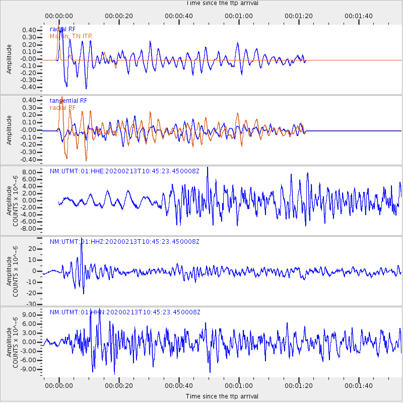
UTMT Martin, TN - Earthquake Result Viewer
*The percent match for this event was below the threshold and hence no stack was calculated.
| Earthquake location: |
Kuril Islands |
| Earthquake latitude/longitude: |
45.6/148.9 |
| Earthquake time(UTC): |
2020/02/13 (044) 10:33:44 GMT |
| Earthquake Depth: |
144 km |
| Earthquake Magnitude: |
7.0 mww |
| Earthquake Catalog/Contributor: |
NEIC PDE/us |
|
| Network: |
NM Cooperative New Madrid Seismic Network |
| Station: |
UTMT Martin, TN |
| Lat/Lon: |
36.35 N/88.86 W |
| Elevation: |
110 m |
|
| Distance: |
83.2 deg |
| Az: |
43.467 deg |
| Baz: |
323.279 deg |
| Ray Param: |
$rayparam |
*The percent match for this event was below the threshold and hence was not used in the summary stack. |
|
| Radial Match: |
75.39822 % |
| Radial Bump: |
400 |
| Transverse Match: |
47.920357 % |
| Transverse Bump: |
396 |
| SOD ConfigId: |
20792311 |
| Insert Time: |
2020-03-06 16:06:52.156 +0000 |
| GWidth: |
2.5 |
| Max Bumps: |
400 |
| Tol: |
0.001 |
|
Signal To Noise
| Channel | StoN | STA | LTA |
| NM:UTMT:01:HHZ:20200213T10:45:23.450008Z | 3.1690824 | 3.2684543E-6 | 1.0313566E-6 |
| NM:UTMT:01:HHN:20200213T10:45:23.450008Z | 1.1102312 | 1.3112602E-6 | 1.1810696E-6 |
| NM:UTMT:01:HHE:20200213T10:45:23.450008Z | 0.9047498 | 1.0649118E-6 | 1.1770235E-6 |
| Arrivals |
| Ps | |
| PpPs | |
| PsPs/PpSs | |


