You are here: Home > Network List > PE - Penn State Network Stations List
> Station PAGS PA Geological Survey, Middletown, PA > Earthquake Result Viewer
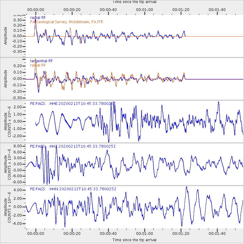
PAGS PA Geological Survey, Middletown, PA - Earthquake Result Viewer
*The percent match for this event was below the threshold and hence no stack was calculated.
| Earthquake location: |
Kuril Islands |
| Earthquake latitude/longitude: |
45.6/148.9 |
| Earthquake time(UTC): |
2020/02/13 (044) 10:33:44 GMT |
| Earthquake Depth: |
144 km |
| Earthquake Magnitude: |
7.0 mww |
| Earthquake Catalog/Contributor: |
NEIC PDE/us |
|
| Network: |
PE Penn State Network |
| Station: |
PAGS PA Geological Survey, Middletown, PA |
| Lat/Lon: |
40.23 N/76.72 W |
| Elevation: |
120 m |
|
| Distance: |
85.2 deg |
| Az: |
33.322 deg |
| Baz: |
329.77 deg |
| Ray Param: |
$rayparam |
*The percent match for this event was below the threshold and hence was not used in the summary stack. |
|
| Radial Match: |
69.899864 % |
| Radial Bump: |
364 |
| Transverse Match: |
73.5339 % |
| Transverse Bump: |
400 |
| SOD ConfigId: |
20792311 |
| Insert Time: |
2020-03-06 16:33:04.632 +0000 |
| GWidth: |
2.5 |
| Max Bumps: |
400 |
| Tol: |
0.001 |
|
Signal To Noise
| Channel | StoN | STA | LTA |
| PE:PAGS: :HHZ:20200213T10:45:33.780025Z | 3.1029549 | 4.1321728E-6 | 1.3316895E-6 |
| PE:PAGS: :HHN:20200213T10:45:33.780025Z | 0.85927576 | 1.0114186E-6 | 1.1770594E-6 |
| PE:PAGS: :HHE:20200213T10:45:33.780025Z | 0.7079876 | 5.472471E-7 | 7.729614E-7 |
| Arrivals |
| Ps | |
| PpPs | |
| PsPs/PpSs | |


