You are here: Home > Network List > TS - TERRAscope (Southern California Seismic Network) Stations List
> Station PFO Pinon Flat, California, USA > Earthquake Result Viewer
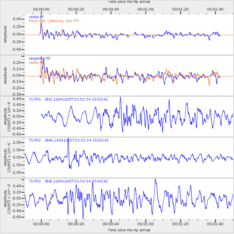
PFO Pinon Flat, California, USA - Earthquake Result Viewer
*The percent match for this event was below the threshold and hence no stack was calculated.
| Earthquake location: |
Kuril Islands |
| Earthquake latitude/longitude: |
43.9/147.4 |
| Earthquake time(UTC): |
1994/10/05 (278) 20:39:47 GMT |
| Earthquake Depth: |
33 km |
| Earthquake Magnitude: |
6.2 MB, 5.6 MS, 5.9 UNKNOWN |
| Earthquake Catalog/Contributor: |
WHDF/NEIC |
|
| Network: |
TS TERRAscope (Southern California Seismic Network) |
| Station: |
PFO Pinon Flat, California, USA |
| Lat/Lon: |
33.61 N/116.46 W |
| Elevation: |
1280 m |
|
| Distance: |
71.6 deg |
| Az: |
60.967 deg |
| Baz: |
310.748 deg |
| Ray Param: |
$rayparam |
*The percent match for this event was below the threshold and hence was not used in the summary stack. |
|
| Radial Match: |
71.896576 % |
| Radial Bump: |
400 |
| Transverse Match: |
69.78722 % |
| Transverse Bump: |
400 |
| SOD ConfigId: |
4480 |
| Insert Time: |
2010-02-26 14:43:07.665 +0000 |
| GWidth: |
2.5 |
| Max Bumps: |
400 |
| Tol: |
0.001 |
|
Signal To Noise
| Channel | StoN | STA | LTA |
| TS:PFO: :BHN:19941005T20:50:34.350024Z | 1.783215 | 5.1770184E-7 | 2.9031935E-7 |
| TS:PFO: :BHE:19941005T20:50:34.350024Z | 0.71364206 | 1.4494097E-7 | 2.0310037E-7 |
| TS:PFO: :BHZ:19941005T20:50:34.350024Z | 1.4285481 | 2.0865998E-7 | 1.4606437E-7 |
| Arrivals |
| Ps | |
| PpPs | |
| PsPs/PpSs | |


