You are here: Home > Network List > TA - USArray Transportable Network (new EarthScope stations) Stations List
> Station E24K Your Creek, AK, USA > Earthquake Result Viewer
E24K Your Creek, AK, USA - Earthquake Result Viewer
| Earthquake location: |
Kuril Islands |
| Earthquake latitude/longitude: |
45.6/148.9 |
| Earthquake time(UTC): |
2020/02/13 (044) 10:33:44 GMT |
| Earthquake Depth: |
144 km |
| Earthquake Magnitude: |
7.0 mww |
| Earthquake Catalog/Contributor: |
NEIC PDE/us |
|
| Network: |
TA USArray Transportable Network (new EarthScope stations) |
| Station: |
E24K Your Creek, AK, USA |
| Lat/Lon: |
68.07 N/148.49 W |
| Elevation: |
847 m |
|
| Distance: |
38.6 deg |
| Az: |
32.313 deg |
| Baz: |
267.073 deg |
| Ray Param: |
0.07497199 |
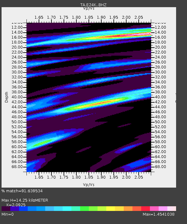
| Estimated Moho Depth: |
14.25 km |
| Estimated Crust Vp/Vs: |
2.09 |
| Assumed Crust Vp: |
6.316 km/s |
| Estimated Crust Vs: |
3.019 km/s |
| Estimated Crust Poisson's Ratio: |
0.35 |
|
| Radial Match: |
91.639534 % |
| Radial Bump: |
400 |
| Transverse Match: |
85.35951 % |
| Transverse Bump: |
400 |
| SOD ConfigId: |
20792311 |
| Insert Time: |
2020-03-06 17:10:29.163 +0000 |
| GWidth: |
2.5 |
| Max Bumps: |
400 |
| Tol: |
0.001 |
|

Signal To Noise
| Channel | StoN | STA | LTA |
| TA:E24K: :BHZ:20200213T10:40:23.02499Z | 52.368828 | 9.921109E-6 | 1.8944685E-7 |
| TA:E24K: :BHN:20200213T10:40:23.02499Z | 6.8360577 | 9.798661E-7 | 1.4333789E-7 |
| TA:E24K: :BHE:20200213T10:40:23.02499Z | 20.14355 | 4.587054E-6 | 2.2771825E-7 |
| Arrivals |
| Ps | 2.6 SECOND |
| PpPs | 6.6 SECOND |
| PsPs/PpSs | 9.2 SECOND |


