You are here: Home > Network List > MN - MEDNET Project Stations List
> Station VTS Vitosha, Bulgary > Earthquake Result Viewer
VTS Vitosha, Bulgary - Earthquake Result Viewer
*The percent match for this event was below the threshold and hence no stack was calculated.
| Earthquake location: |
Kuril Islands |
| Earthquake latitude/longitude: |
43.1/146.5 |
| Earthquake time(UTC): |
2008/03/13 (073) 08:41:07 GMT |
| Earthquake Depth: |
53 km |
| Earthquake Magnitude: |
5.6 MB, 5.4 MW, 5.3 MW |
| Earthquake Catalog/Contributor: |
WHDF/NEIC |
|
| Network: |
MN MEDNET Project |
| Station: |
VTS Vitosha, Bulgary |
| Lat/Lon: |
42.62 N/23.24 E |
| Elevation: |
1490 m |
|
| Distance: |
80.7 deg |
| Az: |
321.298 deg |
| Baz: |
38.373 deg |
| Ray Param: |
$rayparam |
*The percent match for this event was below the threshold and hence was not used in the summary stack. |
|
| Radial Match: |
45.413082 % |
| Radial Bump: |
400 |
| Transverse Match: |
49.36058 % |
| Transverse Bump: |
400 |
| SOD ConfigId: |
2504 |
| Insert Time: |
2010-03-08 17:59:31.819 +0000 |
| GWidth: |
2.5 |
| Max Bumps: |
400 |
| Tol: |
0.001 |
|
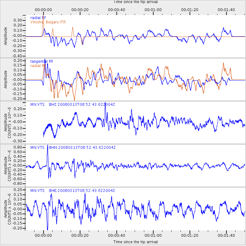
Signal To Noise
| Channel | StoN | STA | LTA |
| MN:VTS: :BHN:20080313T08:52:43.622004Z | 3.7903662 | 3.1367512E-7 | 8.275589E-8 |
| MN:VTS: :BHE:20080313T08:52:43.622004Z | 2.053338 | 1.0443181E-7 | 5.0859533E-8 |
| MN:VTS: :BHZ:20080313T08:52:43.622004Z | 1.4792302 | 1.1885292E-7 | 8.0347824E-8 |
| Arrivals |
| Ps | |
| PpPs | |
| PsPs/PpSs | |


