You are here: Home > Network List > TA - USArray Transportable Network (new EarthScope stations) Stations List
> Station G27K Doyon Strip, AK, USA > Earthquake Result Viewer
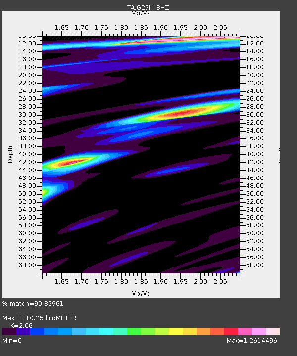
G27K Doyon Strip, AK, USA - Earthquake Result Viewer
| Earthquake location: |
Kuril Islands |
| Earthquake latitude/longitude: |
45.6/148.9 |
| Earthquake time(UTC): |
2020/02/13 (044) 10:33:44 GMT |
| Earthquake Depth: |
144 km |
| Earthquake Magnitude: |
7.0 mww |
| Earthquake Catalog/Contributor: |
NEIC PDE/us |
|
| Network: |
TA USArray Transportable Network (new EarthScope stations) |
| Station: |
G27K Doyon Strip, AK, USA |
| Lat/Lon: |
66.81 N/141.65 W |
| Elevation: |
686 m |
|
| Distance: |
41.2 deg |
| Az: |
34.223 deg |
| Baz: |
274.843 deg |
| Ray Param: |
0.07336944 |
| Estimated Moho Depth: |
10.25 km |
| Estimated Crust Vp/Vs: |
2.06 |
| Assumed Crust Vp: |
6.577 km/s |
| Estimated Crust Vs: |
3.193 km/s |
| Estimated Crust Poisson's Ratio: |
0.35 |
|
| Radial Match: |
90.85961 % |
| Radial Bump: |
400 |
| Transverse Match: |
79.12065 % |
| Transverse Bump: |
400 |
| SOD ConfigId: |
20792311 |
| Insert Time: |
2020-03-06 17:13:05.558 +0000 |
| GWidth: |
2.5 |
| Max Bumps: |
400 |
| Tol: |
0.001 |
|

Signal To Noise
| Channel | StoN | STA | LTA |
| TA:G27K: :BHZ:20200213T10:40:44.89999Z | 19.883512 | 4.536339E-6 | 2.2814577E-7 |
| TA:G27K: :BHN:20200213T10:40:44.89999Z | 1.5974648 | 6.7821827E-7 | 4.2455915E-7 |
| TA:G27K: :BHE:20200213T10:40:44.89999Z | 7.897484 | 2.3936238E-6 | 3.030869E-7 |
| Arrivals |
| Ps | 1.8 SECOND |
| PpPs | 4.5 SECOND |
| PsPs/PpSs | 6.2 SECOND |


