You are here: Home > Network List > TA - USArray Transportable Network (new EarthScope stations) Stations List
> Station G29M Pine Creek, YT, CAN > Earthquake Result Viewer
G29M Pine Creek, YT, CAN - Earthquake Result Viewer
| Earthquake location: |
Kuril Islands |
| Earthquake latitude/longitude: |
45.6/148.9 |
| Earthquake time(UTC): |
2020/02/13 (044) 10:33:44 GMT |
| Earthquake Depth: |
144 km |
| Earthquake Magnitude: |
7.0 mww |
| Earthquake Catalog/Contributor: |
NEIC PDE/us |
|
| Network: |
TA USArray Transportable Network (new EarthScope stations) |
| Station: |
G29M Pine Creek, YT, CAN |
| Lat/Lon: |
66.91 N/138.02 W |
| Elevation: |
572 m |
|
| Distance: |
42.7 deg |
| Az: |
33.831 deg |
| Baz: |
277.889 deg |
| Ray Param: |
0.072512306 |
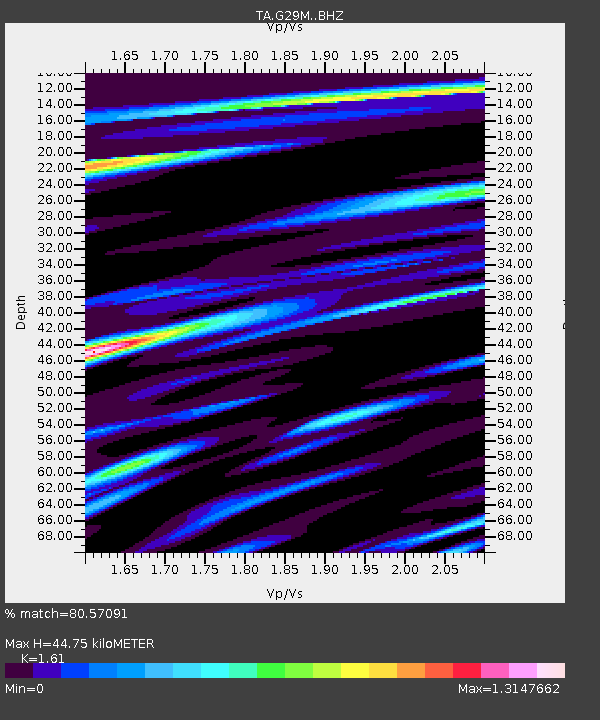
| Estimated Moho Depth: |
44.75 km |
| Estimated Crust Vp/Vs: |
1.61 |
| Assumed Crust Vp: |
6.577 km/s |
| Estimated Crust Vs: |
4.085 km/s |
| Estimated Crust Poisson's Ratio: |
0.19 |
|
| Radial Match: |
80.57091 % |
| Radial Bump: |
400 |
| Transverse Match: |
81.04724 % |
| Transverse Bump: |
400 |
| SOD ConfigId: |
20792311 |
| Insert Time: |
2020-03-06 17:13:14.629 +0000 |
| GWidth: |
2.5 |
| Max Bumps: |
400 |
| Tol: |
0.001 |
|

Signal To Noise
| Channel | StoN | STA | LTA |
| TA:G29M: :BHZ:20200213T10:40:56.350002Z | 22.685093 | 7.768756E-6 | 3.4246085E-7 |
| TA:G29M: :BHN:20200213T10:40:56.350002Z | 1.0734279 | 5.2888583E-7 | 4.927074E-7 |
| TA:G29M: :BHE:20200213T10:40:56.350002Z | 5.847962 | 2.4538642E-6 | 4.196102E-7 |
| Arrivals |
| Ps | 4.5 SECOND |
| PpPs | 16 SECOND |
| PsPs/PpSs | 21 SECOND |


