You are here: Home > Network List > TA - USArray Transportable Network (new EarthScope stations) Stations List
> Station I17K Unalakleet, AK, USA > Earthquake Result Viewer
I17K Unalakleet, AK, USA - Earthquake Result Viewer
| Earthquake location: |
Kuril Islands |
| Earthquake latitude/longitude: |
45.6/148.9 |
| Earthquake time(UTC): |
2020/02/13 (044) 10:33:44 GMT |
| Earthquake Depth: |
144 km |
| Earthquake Magnitude: |
7.0 mww |
| Earthquake Catalog/Contributor: |
NEIC PDE/us |
|
| Network: |
TA USArray Transportable Network (new EarthScope stations) |
| Station: |
I17K Unalakleet, AK, USA |
| Lat/Lon: |
63.89 N/160.70 W |
| Elevation: |
105 m |
|
| Distance: |
33.2 deg |
| Az: |
38.526 deg |
| Baz: |
260.961 deg |
| Ray Param: |
0.077899635 |
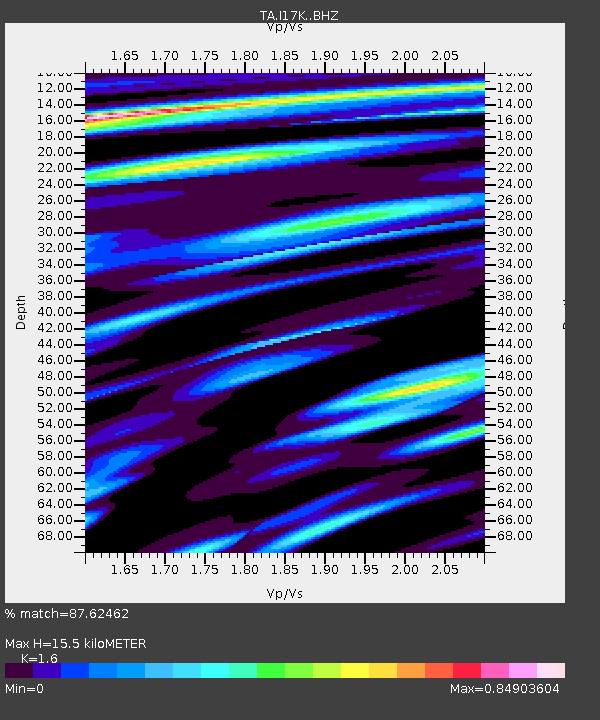
| Estimated Moho Depth: |
15.5 km |
| Estimated Crust Vp/Vs: |
1.60 |
| Assumed Crust Vp: |
6.276 km/s |
| Estimated Crust Vs: |
3.922 km/s |
| Estimated Crust Poisson's Ratio: |
0.18 |
|
| Radial Match: |
87.62462 % |
| Radial Bump: |
392 |
| Transverse Match: |
63.86335 % |
| Transverse Bump: |
400 |
| SOD ConfigId: |
20792311 |
| Insert Time: |
2020-03-06 17:14:25.156 +0000 |
| GWidth: |
2.5 |
| Max Bumps: |
400 |
| Tol: |
0.001 |
|

Signal To Noise
| Channel | StoN | STA | LTA |
| TA:I17K: :BHZ:20200213T10:39:37.100002Z | 11.795337 | 5.3085155E-6 | 4.5005203E-7 |
| TA:I17K: :BHN:20200213T10:39:37.100002Z | 1.9900695 | 6.219449E-7 | 3.125242E-7 |
| TA:I17K: :BHE:20200213T10:39:37.100002Z | 10.401119 | 2.6205896E-6 | 2.5195266E-7 |
| Arrivals |
| Ps | 1.6 SECOND |
| PpPs | 5.9 SECOND |
| PsPs/PpSs | 7.5 SECOND |


