You are here: Home > Network List > TA - USArray Transportable Network (new EarthScope stations) Stations List
> Station I29M Ogilvie Camp, Yukon, CA > Earthquake Result Viewer
I29M Ogilvie Camp, Yukon, CA - Earthquake Result Viewer
| Earthquake location: |
Kuril Islands |
| Earthquake latitude/longitude: |
45.6/148.9 |
| Earthquake time(UTC): |
2020/02/13 (044) 10:33:44 GMT |
| Earthquake Depth: |
144 km |
| Earthquake Magnitude: |
7.0 mww |
| Earthquake Catalog/Contributor: |
NEIC PDE/us |
|
| Network: |
TA USArray Transportable Network (new EarthScope stations) |
| Station: |
I29M Ogilvie Camp, Yukon, CA |
| Lat/Lon: |
65.36 N/138.31 W |
| Elevation: |
602 m |
|
| Distance: |
42.8 deg |
| Az: |
36.127 deg |
| Baz: |
279.316 deg |
| Ray Param: |
0.0724373 |
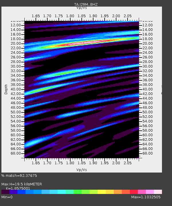
| Estimated Moho Depth: |
19.5 km |
| Estimated Crust Vp/Vs: |
1.86 |
| Assumed Crust Vp: |
6.566 km/s |
| Estimated Crust Vs: |
3.535 km/s |
| Estimated Crust Poisson's Ratio: |
0.30 |
|
| Radial Match: |
92.37675 % |
| Radial Bump: |
381 |
| Transverse Match: |
84.81217 % |
| Transverse Bump: |
400 |
| SOD ConfigId: |
20792311 |
| Insert Time: |
2020-03-06 17:14:38.560 +0000 |
| GWidth: |
2.5 |
| Max Bumps: |
400 |
| Tol: |
0.001 |
|

Signal To Noise
| Channel | StoN | STA | LTA |
| TA:I29M: :BHZ:20200213T10:40:57.300014Z | 39.433144 | 6.8817358E-6 | 1.7451654E-7 |
| TA:I29M: :BHN:20200213T10:40:57.300014Z | 9.935617 | 1.5191104E-6 | 1.5289541E-7 |
| TA:I29M: :BHE:20200213T10:40:57.300014Z | 14.422591 | 3.7646664E-6 | 2.6102566E-7 |
| Arrivals |
| Ps | 2.7 SECOND |
| PpPs | 7.9 SECOND |
| PsPs/PpSs | 11 SECOND |


