You are here: Home > Network List > TA - USArray Transportable Network (new EarthScope stations) Stations List
> Station J29N Klondike Camp, Yukon, CA > Earthquake Result Viewer
J29N Klondike Camp, Yukon, CA - Earthquake Result Viewer
| Earthquake location: |
Kuril Islands |
| Earthquake latitude/longitude: |
45.6/148.9 |
| Earthquake time(UTC): |
2020/02/13 (044) 10:33:44 GMT |
| Earthquake Depth: |
144 km |
| Earthquake Magnitude: |
7.0 mww |
| Earthquake Catalog/Contributor: |
NEIC PDE/us |
|
| Network: |
TA USArray Transportable Network (new EarthScope stations) |
| Station: |
J29N Klondike Camp, Yukon, CA |
| Lat/Lon: |
64.45 N/138.22 W |
| Elevation: |
982 m |
|
| Distance: |
43.0 deg |
| Az: |
37.439 deg |
| Baz: |
280.359 deg |
| Ray Param: |
0.07231206 |
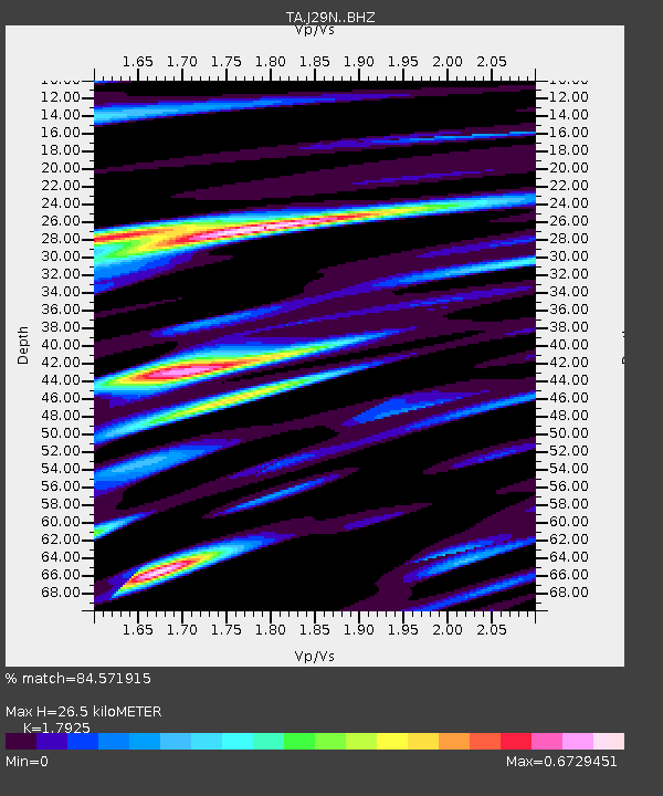
| Estimated Moho Depth: |
26.5 km |
| Estimated Crust Vp/Vs: |
1.79 |
| Assumed Crust Vp: |
6.566 km/s |
| Estimated Crust Vs: |
3.663 km/s |
| Estimated Crust Poisson's Ratio: |
0.27 |
|
| Radial Match: |
84.571915 % |
| Radial Bump: |
400 |
| Transverse Match: |
60.44644 % |
| Transverse Bump: |
400 |
| SOD ConfigId: |
20792311 |
| Insert Time: |
2020-03-06 17:15:08.698 +0000 |
| GWidth: |
2.5 |
| Max Bumps: |
400 |
| Tol: |
0.001 |
|

Signal To Noise
| Channel | StoN | STA | LTA |
| TA:J29N: :BHZ:20200213T10:40:58.874996Z | 11.226121 | 3.0368296E-6 | 2.705146E-7 |
| TA:J29N: :BHN:20200213T10:40:58.874996Z | 2.2459736 | 8.3065083E-7 | 3.6983997E-7 |
| TA:J29N: :BHE:20200213T10:40:58.874996Z | 4.6113286 | 2.0281336E-6 | 4.3981547E-7 |
| Arrivals |
| Ps | 3.4 SECOND |
| PpPs | 11 SECOND |
| PsPs/PpSs | 14 SECOND |


