You are here: Home > Network List > TA - USArray Transportable Network (new EarthScope stations) Stations List
> Station K15K Wolf Creek Mountain, AK, USA > Earthquake Result Viewer
K15K Wolf Creek Mountain, AK, USA - Earthquake Result Viewer
| Earthquake location: |
Kuril Islands |
| Earthquake latitude/longitude: |
45.6/148.9 |
| Earthquake time(UTC): |
2020/02/13 (044) 10:33:44 GMT |
| Earthquake Depth: |
144 km |
| Earthquake Magnitude: |
7.0 mww |
| Earthquake Catalog/Contributor: |
NEIC PDE/us |
|
| Network: |
TA USArray Transportable Network (new EarthScope stations) |
| Station: |
K15K Wolf Creek Mountain, AK, USA |
| Lat/Lon: |
62.29 N/161.53 W |
| Elevation: |
346 m |
|
| Distance: |
32.6 deg |
| Az: |
41.341 deg |
| Baz: |
262.581 deg |
| Ray Param: |
0.07818419 |
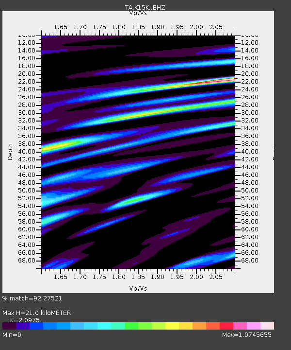
| Estimated Moho Depth: |
21.0 km |
| Estimated Crust Vp/Vs: |
2.10 |
| Assumed Crust Vp: |
6.276 km/s |
| Estimated Crust Vs: |
2.992 km/s |
| Estimated Crust Poisson's Ratio: |
0.35 |
|
| Radial Match: |
92.27521 % |
| Radial Bump: |
400 |
| Transverse Match: |
82.250496 % |
| Transverse Bump: |
400 |
| SOD ConfigId: |
20792311 |
| Insert Time: |
2020-03-06 17:15:25.352 +0000 |
| GWidth: |
2.5 |
| Max Bumps: |
400 |
| Tol: |
0.001 |
|
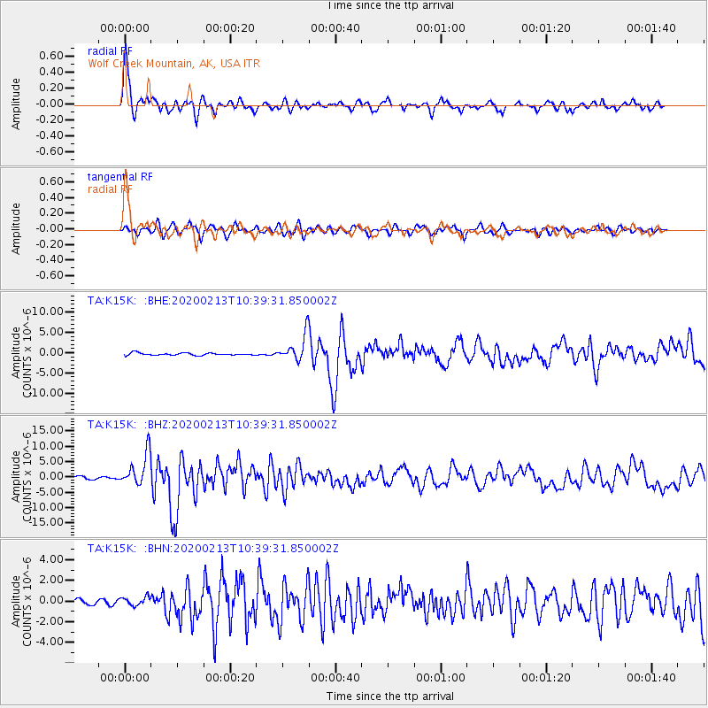
Signal To Noise
| Channel | StoN | STA | LTA |
| TA:K15K: :BHZ:20200213T10:39:31.850002Z | 11.029599 | 5.3881326E-6 | 4.8851575E-7 |
| TA:K15K: :BHN:20200213T10:39:31.850002Z | 1.0471859 | 4.2387393E-7 | 4.0477428E-7 |
| TA:K15K: :BHE:20200213T10:39:31.850002Z | 11.69269 | 3.293134E-6 | 2.8164038E-7 |
| Arrivals |
| Ps | 3.9 SECOND |
| PpPs | 9.7 SECOND |
| PsPs/PpSs | 14 SECOND |


