You are here: Home > Network List > TA - USArray Transportable Network (new EarthScope stations) Stations List
> Station L27K Beaver Creek, Northway Junction, AK, USA > Earthquake Result Viewer
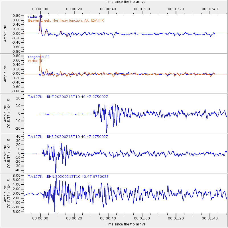
L27K Beaver Creek, Northway Junction, AK, USA - Earthquake Result Viewer

| Earthquake location: |
Kuril Islands |
| Earthquake latitude/longitude: |
45.6/148.9 |
| Earthquake time(UTC): |
2020/02/13 (044) 10:33:44 GMT |
| Earthquake Depth: |
144 km |
| Earthquake Magnitude: |
7.0 mww |
| Earthquake Catalog/Contributor: |
NEIC PDE/us |
|
| Network: |
TA USArray Transportable Network (new EarthScope stations) |
| Station: |
L27K Beaver Creek, Northway Junction, AK, USA |
| Lat/Lon: |
63.06 N/141.83 W |
| Elevation: |
755 m |
|
| Distance: |
41.6 deg |
| Az: |
39.883 deg |
| Baz: |
278.932 deg |
| Ray Param: |
0.07315901 |
| Estimated Moho Depth: |
31.25 km |
| Estimated Crust Vp/Vs: |
1.74 |
| Assumed Crust Vp: |
6.566 km/s |
| Estimated Crust Vs: |
3.768 km/s |
| Estimated Crust Poisson's Ratio: |
0.25 |
|
| Radial Match: |
94.596535 % |
| Radial Bump: |
385 |
| Transverse Match: |
80.55109 % |
| Transverse Bump: |
400 |
| SOD ConfigId: |
20792311 |
| Insert Time: |
2020-03-06 17:16:01.493 +0000 |
| GWidth: |
2.5 |
| Max Bumps: |
400 |
| Tol: |
0.001 |
|
Signal To Noise
| Channel | StoN | STA | LTA |
| TA:L27K: :BHZ:20200213T10:40:47.975002Z | 19.467623 | 6.310001E-6 | 3.2412797E-7 |
| TA:L27K: :BHN:20200213T10:40:47.975002Z | 3.0229492 | 8.351532E-7 | 2.7627098E-7 |
| TA:L27K: :BHE:20200213T10:40:47.975002Z | 17.259293 | 3.7230682E-6 | 2.1571383E-7 |
| Arrivals |
| Ps | 3.8 SECOND |
| PpPs | 12 SECOND |
| PsPs/PpSs | 16 SECOND |


