You are here: Home > Network List > TA - USArray Transportable Network (new EarthScope stations) Stations List
> Station M24K Tolsona, Glennallen, AK, USA > Earthquake Result Viewer
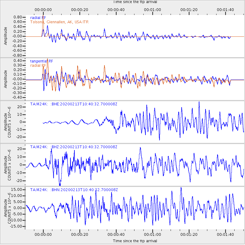
M24K Tolsona, Glennallen, AK, USA - Earthquake Result Viewer
*The percent match for this event was below the threshold and hence no stack was calculated.
| Earthquake location: |
Kuril Islands |
| Earthquake latitude/longitude: |
45.6/148.9 |
| Earthquake time(UTC): |
2020/02/13 (044) 10:33:44 GMT |
| Earthquake Depth: |
144 km |
| Earthquake Magnitude: |
7.0 mww |
| Earthquake Catalog/Contributor: |
NEIC PDE/us |
|
| Network: |
TA USArray Transportable Network (new EarthScope stations) |
| Station: |
M24K Tolsona, Glennallen, AK, USA |
| Lat/Lon: |
62.11 N/146.18 W |
| Elevation: |
908 m |
|
| Distance: |
39.8 deg |
| Az: |
41.754 deg |
| Baz: |
276.497 deg |
| Ray Param: |
$rayparam |
*The percent match for this event was below the threshold and hence was not used in the summary stack. |
|
| Radial Match: |
63.447468 % |
| Radial Bump: |
400 |
| Transverse Match: |
60.603245 % |
| Transverse Bump: |
400 |
| SOD ConfigId: |
20792311 |
| Insert Time: |
2020-03-06 17:17:15.411 +0000 |
| GWidth: |
2.5 |
| Max Bumps: |
400 |
| Tol: |
0.001 |
|
Signal To Noise
| Channel | StoN | STA | LTA |
| TA:M24K: :BHZ:20200213T10:40:32.700008Z | 4.8299994 | 7.0323376E-6 | 1.4559707E-6 |
| TA:M24K: :BHN:20200213T10:40:32.700008Z | 0.96277255 | 1.4923451E-6 | 1.5500494E-6 |
| TA:M24K: :BHE:20200213T10:40:32.700008Z | 2.4023592 | 3.4263724E-6 | 1.4262532E-6 |
| Arrivals |
| Ps | |
| PpPs | |
| PsPs/PpSs | |


