You are here: Home > Network List > TA - USArray Transportable Network (new EarthScope stations) Stations List
> Station N25K Chitina, Valdez-Cordova, AK, USA > Earthquake Result Viewer
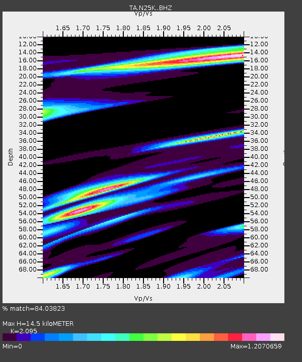
N25K Chitina, Valdez-Cordova, AK, USA - Earthquake Result Viewer
| Earthquake location: |
Kuril Islands |
| Earthquake latitude/longitude: |
45.6/148.9 |
| Earthquake time(UTC): |
2020/02/13 (044) 10:33:44 GMT |
| Earthquake Depth: |
144 km |
| Earthquake Magnitude: |
7.0 mww |
| Earthquake Catalog/Contributor: |
NEIC PDE/us |
|
| Network: |
TA USArray Transportable Network (new EarthScope stations) |
| Station: |
N25K Chitina, Valdez-Cordova, AK, USA |
| Lat/Lon: |
61.61 N/144.60 W |
| Elevation: |
1087 m |
|
| Distance: |
40.6 deg |
| Az: |
42.376 deg |
| Baz: |
278.361 deg |
| Ray Param: |
0.07379992 |
| Estimated Moho Depth: |
14.5 km |
| Estimated Crust Vp/Vs: |
2.10 |
| Assumed Crust Vp: |
6.566 km/s |
| Estimated Crust Vs: |
3.134 km/s |
| Estimated Crust Poisson's Ratio: |
0.35 |
|
| Radial Match: |
84.03823 % |
| Radial Bump: |
400 |
| Transverse Match: |
57.132973 % |
| Transverse Bump: |
400 |
| SOD ConfigId: |
20792311 |
| Insert Time: |
2020-03-06 17:18:16.395 +0000 |
| GWidth: |
2.5 |
| Max Bumps: |
400 |
| Tol: |
0.001 |
|

Signal To Noise
| Channel | StoN | STA | LTA |
| TA:N25K: :BHZ:20200213T10:40:39.325008Z | 12.761024 | 3.6295262E-6 | 2.8442278E-7 |
| TA:N25K: :BHN:20200213T10:40:39.325008Z | 1.4033705 | 5.069922E-7 | 3.6126752E-7 |
| TA:N25K: :BHE:20200213T10:40:39.325008Z | 6.3253083 | 2.5461284E-6 | 4.025303E-7 |
| Arrivals |
| Ps | 2.6 SECOND |
| PpPs | 6.4 SECOND |
| PsPs/PpSs | 9.0 SECOND |


