You are here: Home > Network List > TA - USArray Transportable Network (new EarthScope stations) Stations List
> Station N32M Quiet Lake, YT, Canada > Earthquake Result Viewer
N32M Quiet Lake, YT, Canada - Earthquake Result Viewer
| Earthquake location: |
Kuril Islands |
| Earthquake latitude/longitude: |
45.6/148.9 |
| Earthquake time(UTC): |
2020/02/13 (044) 10:33:44 GMT |
| Earthquake Depth: |
144 km |
| Earthquake Magnitude: |
7.0 mww |
| Earthquake Catalog/Contributor: |
NEIC PDE/us |
|
| Network: |
TA USArray Transportable Network (new EarthScope stations) |
| Station: |
N32M Quiet Lake, YT, Canada |
| Lat/Lon: |
61.15 N/133.08 W |
| Elevation: |
816 m |
|
| Distance: |
46.1 deg |
| Az: |
41.208 deg |
| Baz: |
287.611 deg |
| Ray Param: |
0.07037616 |
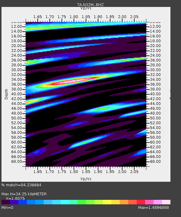
| Estimated Moho Depth: |
34.25 km |
| Estimated Crust Vp/Vs: |
1.81 |
| Assumed Crust Vp: |
6.419 km/s |
| Estimated Crust Vs: |
3.551 km/s |
| Estimated Crust Poisson's Ratio: |
0.28 |
|
| Radial Match: |
84.236664 % |
| Radial Bump: |
400 |
| Transverse Match: |
64.67792 % |
| Transverse Bump: |
400 |
| SOD ConfigId: |
20792311 |
| Insert Time: |
2020-03-06 17:18:29.919 +0000 |
| GWidth: |
2.5 |
| Max Bumps: |
400 |
| Tol: |
0.001 |
|
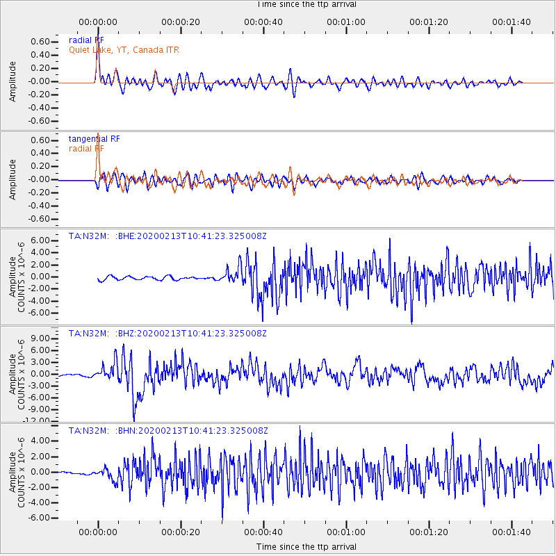
Signal To Noise
| Channel | StoN | STA | LTA |
| TA:N32M: :BHZ:20200213T10:41:23.325008Z | 7.2005086 | 2.3346668E-6 | 3.2423634E-7 |
| TA:N32M: :BHN:20200213T10:41:23.325008Z | 2.8794122 | 7.895225E-7 | 2.7419574E-7 |
| TA:N32M: :BHE:20200213T10:41:23.325008Z | 4.673042 | 1.3734752E-6 | 2.939146E-7 |
| Arrivals |
| Ps | 4.6 SECOND |
| PpPs | 14 SECOND |
| PsPs/PpSs | 19 SECOND |


