You are here: Home > Network List > TA - USArray Transportable Network (new EarthScope stations) Stations List
> Station P18K Big Mountain, AK, USA > Earthquake Result Viewer
P18K Big Mountain, AK, USA - Earthquake Result Viewer
| Earthquake location: |
Kuril Islands |
| Earthquake latitude/longitude: |
45.6/148.9 |
| Earthquake time(UTC): |
2020/02/13 (044) 10:33:44 GMT |
| Earthquake Depth: |
144 km |
| Earthquake Magnitude: |
7.0 mww |
| Earthquake Catalog/Contributor: |
NEIC PDE/us |
|
| Network: |
TA USArray Transportable Network (new EarthScope stations) |
| Station: |
P18K Big Mountain, AK, USA |
| Lat/Lon: |
59.39 N/155.23 W |
| Elevation: |
680 m |
|
| Distance: |
35.5 deg |
| Az: |
46.762 deg |
| Baz: |
272.573 deg |
| Ray Param: |
0.076700844 |
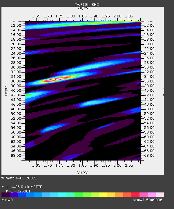
| Estimated Moho Depth: |
35.0 km |
| Estimated Crust Vp/Vs: |
1.73 |
| Assumed Crust Vp: |
6.438 km/s |
| Estimated Crust Vs: |
3.716 km/s |
| Estimated Crust Poisson's Ratio: |
0.25 |
|
| Radial Match: |
86.70371 % |
| Radial Bump: |
400 |
| Transverse Match: |
68.56486 % |
| Transverse Bump: |
400 |
| SOD ConfigId: |
20792311 |
| Insert Time: |
2020-03-06 17:19:22.077 +0000 |
| GWidth: |
2.5 |
| Max Bumps: |
400 |
| Tol: |
0.001 |
|

Signal To Noise
| Channel | StoN | STA | LTA |
| TA:P18K: :BHZ:20200213T10:39:57.325008Z | 8.316393 | 5.821383E-6 | 6.9998896E-7 |
| TA:P18K: :BHN:20200213T10:39:57.325008Z | 0.93408585 | 8.906569E-7 | 9.535065E-7 |
| TA:P18K: :BHE:20200213T10:39:57.325008Z | 2.8700857 | 3.1678983E-6 | 1.1037644E-6 |
| Arrivals |
| Ps | 4.3 SECOND |
| PpPs | 14 SECOND |
| PsPs/PpSs | 18 SECOND |


