You are here: Home > Network List > TA - USArray Transportable Network (new EarthScope stations) Stations List
> Station T35M Bob Quinn, BC, CAN > Earthquake Result Viewer
T35M Bob Quinn, BC, CAN - Earthquake Result Viewer

| Earthquake location: |
Kuril Islands |
| Earthquake latitude/longitude: |
45.6/148.9 |
| Earthquake time(UTC): |
2020/02/13 (044) 10:33:44 GMT |
| Earthquake Depth: |
144 km |
| Earthquake Magnitude: |
7.0 mww |
| Earthquake Catalog/Contributor: |
NEIC PDE/us |
|
| Network: |
TA USArray Transportable Network (new EarthScope stations) |
| Station: |
T35M Bob Quinn, BC, CAN |
| Lat/Lon: |
56.98 N/130.25 W |
| Elevation: |
609 m |
|
| Distance: |
48.9 deg |
| Az: |
45.836 deg |
| Baz: |
293.168 deg |
| Ray Param: |
0.0685701 |
| Estimated Moho Depth: |
10.0 km |
| Estimated Crust Vp/Vs: |
1.60 |
| Assumed Crust Vp: |
6.597 km/s |
| Estimated Crust Vs: |
4.123 km/s |
| Estimated Crust Poisson's Ratio: |
0.18 |
|
| Radial Match: |
86.48864 % |
| Radial Bump: |
400 |
| Transverse Match: |
74.16742 % |
| Transverse Bump: |
400 |
| SOD ConfigId: |
20792311 |
| Insert Time: |
2020-03-06 17:20:58.333 +0000 |
| GWidth: |
2.5 |
| Max Bumps: |
400 |
| Tol: |
0.001 |
|
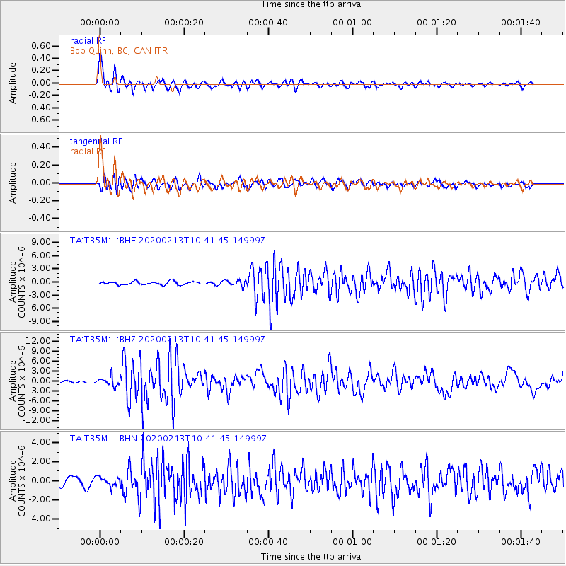
Signal To Noise
| Channel | StoN | STA | LTA |
| TA:T35M: :BHZ:20200213T10:41:45.14999Z | 3.3367488 | 1.3090283E-6 | 3.9230653E-7 |
| TA:T35M: :BHN:20200213T10:41:45.14999Z | 1.0832163 | 4.739277E-7 | 4.37519E-7 |
| TA:T35M: :BHE:20200213T10:41:45.14999Z | 1.8668284 | 6.55346E-7 | 3.510478E-7 |
| Arrivals |
| Ps | 1.0 SECOND |
| PpPs | 3.7 SECOND |
| PsPs/PpSs | 4.7 SECOND |


