You are here: Home > Network List > TX - Texas Seismological Network Stations List
> Station PB06 Permian Basin 6 > Earthquake Result Viewer
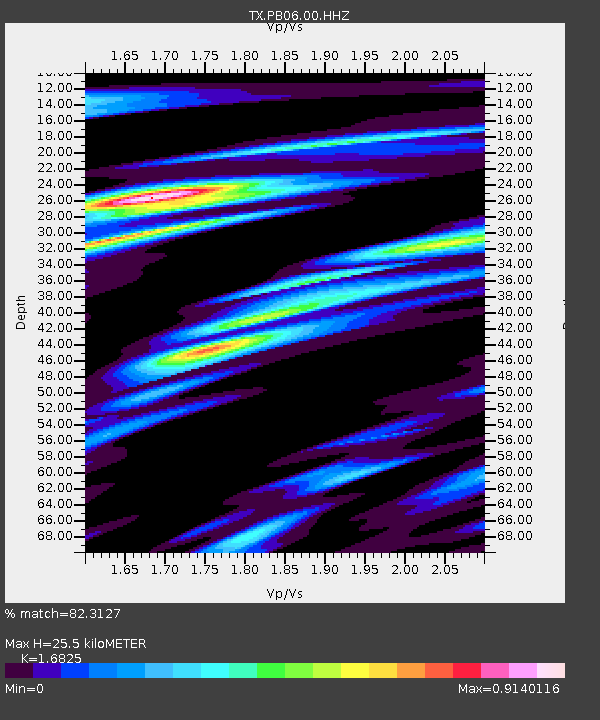
PB06 Permian Basin 6 - Earthquake Result Viewer
| Earthquake location: |
Kuril Islands |
| Earthquake latitude/longitude: |
45.6/148.9 |
| Earthquake time(UTC): |
2020/02/13 (044) 10:33:44 GMT |
| Earthquake Depth: |
144 km |
| Earthquake Magnitude: |
7.0 mww |
| Earthquake Catalog/Contributor: |
NEIC PDE/us |
|
| Network: |
TX Texas Seismological Network |
| Station: |
PB06 Permian Basin 6 |
| Lat/Lon: |
31.65 N/103.22 W |
| Elevation: |
831 m |
|
| Distance: |
79.1 deg |
| Az: |
55.754 deg |
| Baz: |
317.15 deg |
| Ray Param: |
0.048828077 |
| Estimated Moho Depth: |
25.5 km |
| Estimated Crust Vp/Vs: |
1.68 |
| Assumed Crust Vp: |
6.121 km/s |
| Estimated Crust Vs: |
3.638 km/s |
| Estimated Crust Poisson's Ratio: |
0.23 |
|
| Radial Match: |
82.3127 % |
| Radial Bump: |
400 |
| Transverse Match: |
68.05926 % |
| Transverse Bump: |
400 |
| SOD ConfigId: |
20792311 |
| Insert Time: |
2020-03-06 17:32:32.127 +0000 |
| GWidth: |
2.5 |
| Max Bumps: |
400 |
| Tol: |
0.001 |
|

Signal To Noise
| Channel | StoN | STA | LTA |
| TX:PB06:00:HHZ:20200213T10:45:02.090022Z | 4.0895095 | 1.1293182E-6 | 2.7615005E-7 |
| TX:PB06:00:HH1:20200213T10:45:02.090022Z | 0.9974206 | 2.9820742E-7 | 2.989786E-7 |
| TX:PB06:00:HH2:20200213T10:45:02.090022Z | 1.254316 | 2.4194307E-7 | 1.9288846E-7 |
| Arrivals |
| Ps | 2.9 SECOND |
| PpPs | 11 SECOND |
| PsPs/PpSs | 14 SECOND |


