You are here: Home > Network List > TX - Texas Seismological Network Stations List
> Station PB08 Permian Basin 08 > Earthquake Result Viewer
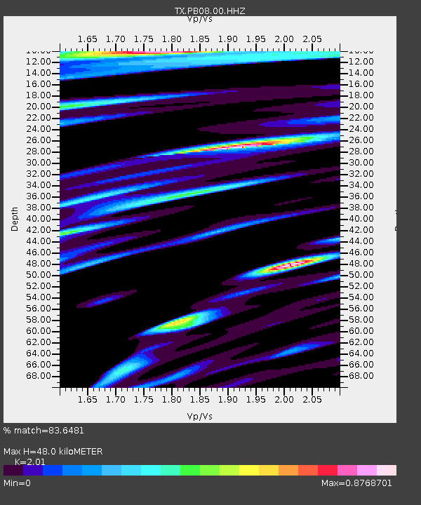
PB08 Permian Basin 08 - Earthquake Result Viewer
| Earthquake location: |
Kuril Islands |
| Earthquake latitude/longitude: |
45.6/148.9 |
| Earthquake time(UTC): |
2020/02/13 (044) 10:33:44 GMT |
| Earthquake Depth: |
144 km |
| Earthquake Magnitude: |
7.0 mww |
| Earthquake Catalog/Contributor: |
NEIC PDE/us |
|
| Network: |
TX Texas Seismological Network |
| Station: |
PB08 Permian Basin 08 |
| Lat/Lon: |
30.89 N/102.91 W |
| Elevation: |
926 m |
|
| Distance: |
79.9 deg |
| Az: |
56.075 deg |
| Baz: |
317.369 deg |
| Ray Param: |
0.04833128 |
| Estimated Moho Depth: |
48.0 km |
| Estimated Crust Vp/Vs: |
2.01 |
| Assumed Crust Vp: |
6.121 km/s |
| Estimated Crust Vs: |
3.045 km/s |
| Estimated Crust Poisson's Ratio: |
0.34 |
|
| Radial Match: |
83.6481 % |
| Radial Bump: |
400 |
| Transverse Match: |
84.864235 % |
| Transverse Bump: |
400 |
| SOD ConfigId: |
20792311 |
| Insert Time: |
2020-03-06 17:32:43.711 +0000 |
| GWidth: |
2.5 |
| Max Bumps: |
400 |
| Tol: |
0.001 |
|

Signal To Noise
| Channel | StoN | STA | LTA |
| TX:PB08:00:HHZ:20200213T10:45:06.039974Z | 1.9127383 | 1.1804831E-6 | 6.171692E-7 |
| TX:PB08:00:HH1:20200213T10:45:06.039974Z | 1.6140049 | 3.847584E-7 | 2.383874E-7 |
| TX:PB08:00:HH2:20200213T10:45:06.039974Z | 2.1132293 | 4.2385113E-7 | 2.0057034E-7 |
| Arrivals |
| Ps | 8.1 SECOND |
| PpPs | 23 SECOND |
| PsPs/PpSs | 31 SECOND |


