You are here: Home > Network List > TX - Texas Seismological Network Stations List
> Station PB14 Weatherby Road > Earthquake Result Viewer
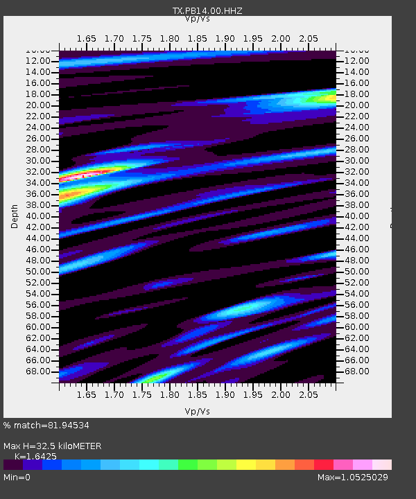
PB14 Weatherby Road - Earthquake Result Viewer
| Earthquake location: |
Kuril Islands |
| Earthquake latitude/longitude: |
45.6/148.9 |
| Earthquake time(UTC): |
2020/02/13 (044) 10:33:44 GMT |
| Earthquake Depth: |
144 km |
| Earthquake Magnitude: |
7.0 mww |
| Earthquake Catalog/Contributor: |
NEIC PDE/us |
|
| Network: |
TX Texas Seismological Network |
| Station: |
PB14 Weatherby Road |
| Lat/Lon: |
31.13 N/103.15 W |
| Elevation: |
807 m |
|
| Distance: |
79.5 deg |
| Az: |
56.068 deg |
| Baz: |
317.243 deg |
| Ray Param: |
0.04854885 |
| Estimated Moho Depth: |
32.5 km |
| Estimated Crust Vp/Vs: |
1.64 |
| Assumed Crust Vp: |
6.121 km/s |
| Estimated Crust Vs: |
3.726 km/s |
| Estimated Crust Poisson's Ratio: |
0.21 |
|
| Radial Match: |
81.94534 % |
| Radial Bump: |
400 |
| Transverse Match: |
81.09185 % |
| Transverse Bump: |
400 |
| SOD ConfigId: |
20792311 |
| Insert Time: |
2020-03-06 17:33:17.717 +0000 |
| GWidth: |
2.5 |
| Max Bumps: |
400 |
| Tol: |
0.001 |
|

Signal To Noise
| Channel | StoN | STA | LTA |
| TX:PB14:00:HHZ:20200213T10:45:04.345027Z | 3.5319653 | 0.0011292909 | 3.1973442E-4 |
| TX:PB14:00:HHN:20200213T10:45:04.345027Z | 1.5406421 | 3.5960804E-4 | 2.3341438E-4 |
| TX:PB14:00:HHE:20200213T10:45:04.345027Z | 1.3848506 | 3.0774152E-4 | 2.2222003E-4 |
| Arrivals |
| Ps | 3.5 SECOND |
| PpPs | 14 SECOND |
| PsPs/PpSs | 17 SECOND |


