You are here: Home > Network List > TX - Texas Seismological Network Stations List
> Station PB16 Coyonosa > Earthquake Result Viewer
PB16 Coyonosa - Earthquake Result Viewer
| Earthquake location: |
Kuril Islands |
| Earthquake latitude/longitude: |
45.6/148.9 |
| Earthquake time(UTC): |
2020/02/13 (044) 10:33:44 GMT |
| Earthquake Depth: |
144 km |
| Earthquake Magnitude: |
7.0 mww |
| Earthquake Catalog/Contributor: |
NEIC PDE/us |
|
| Network: |
TX Texas Seismological Network |
| Station: |
PB16 Coyonosa |
| Lat/Lon: |
31.12 N/103.25 W |
| Elevation: |
848 m |
|
| Distance: |
79.5 deg |
| Az: |
56.135 deg |
| Baz: |
317.203 deg |
| Ray Param: |
0.048586506 |
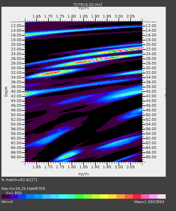
| Estimated Moho Depth: |
26.25 km |
| Estimated Crust Vp/Vs: |
1.90 |
| Assumed Crust Vp: |
6.121 km/s |
| Estimated Crust Vs: |
3.213 km/s |
| Estimated Crust Poisson's Ratio: |
0.31 |
|
| Radial Match: |
92.62271 % |
| Radial Bump: |
384 |
| Transverse Match: |
77.14423 % |
| Transverse Bump: |
400 |
| SOD ConfigId: |
20792311 |
| Insert Time: |
2020-03-06 17:33:30.247 +0000 |
| GWidth: |
2.5 |
| Max Bumps: |
400 |
| Tol: |
0.001 |
|

Signal To Noise
| Channel | StoN | STA | LTA |
| TX:PB16:00:HHZ:20200213T10:45:04.049983Z | 4.426796 | 1.4334926E-6 | 3.238217E-7 |
| TX:PB16:00:HH1:20200213T10:45:04.049983Z | 1.3639078 | 3.4486064E-7 | 2.5284746E-7 |
| TX:PB16:00:HH2:20200213T10:45:04.049983Z | 3.9914887 | 8.444686E-7 | 2.1156734E-7 |
| Arrivals |
| Ps | 4.0 SECOND |
| PpPs | 12 SECOND |
| PsPs/PpSs | 16 SECOND |


