You are here: Home > Network List > UO - University of Oregon Regional Network Stations List
> Station NATH Oakridge, OR, USA > Earthquake Result Viewer
NATH Oakridge, OR, USA - Earthquake Result Viewer
| Earthquake location: |
Kuril Islands |
| Earthquake latitude/longitude: |
45.6/148.9 |
| Earthquake time(UTC): |
2020/02/13 (044) 10:33:44 GMT |
| Earthquake Depth: |
144 km |
| Earthquake Magnitude: |
7.0 mww |
| Earthquake Catalog/Contributor: |
NEIC PDE/us |
|
| Network: |
UO University of Oregon Regional Network |
| Station: |
NATH Oakridge, OR, USA |
| Lat/Lon: |
43.79 N/122.41 W |
| Elevation: |
729 m |
|
| Distance: |
59.8 deg |
| Az: |
56.906 deg |
| Baz: |
305.731 deg |
| Ray Param: |
0.06153245 |
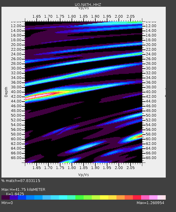
| Estimated Moho Depth: |
41.75 km |
| Estimated Crust Vp/Vs: |
1.64 |
| Assumed Crust Vp: |
6.522 km/s |
| Estimated Crust Vs: |
3.971 km/s |
| Estimated Crust Poisson's Ratio: |
0.21 |
|
| Radial Match: |
87.833115 % |
| Radial Bump: |
400 |
| Transverse Match: |
72.56733 % |
| Transverse Bump: |
400 |
| SOD ConfigId: |
20792311 |
| Insert Time: |
2020-03-06 17:38:27.902 +0000 |
| GWidth: |
2.5 |
| Max Bumps: |
400 |
| Tol: |
0.001 |
|

Signal To Noise
| Channel | StoN | STA | LTA |
| UO:NATH: :HHZ:20200213T10:43:03.697994Z | 6.8263555 | 1.5213551E-6 | 2.2286491E-7 |
| UO:NATH: :HHN:20200213T10:43:03.697994Z | 3.2268956 | 7.540145E-7 | 2.3366559E-7 |
| UO:NATH: :HHE:20200213T10:43:03.697994Z | 3.3223984 | 6.2051424E-7 | 1.8676697E-7 |
| Arrivals |
| Ps | 4.3 SECOND |
| PpPs | 16 SECOND |
| PsPs/PpSs | 20 SECOND |


